Bears Ears to Monument Valley

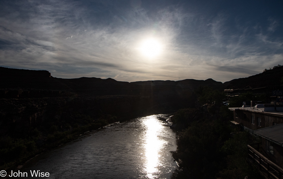
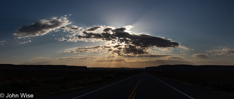
Fifteen-hour days don’t offer much time for blogging when those hours are being actively used for exploring. Yesterday was a good example of that with all motion and no pausing. At the moment, I’m finally sitting down to write. It’s 4:00 pm on the same day, and we have an hour to spare as we await Cody, who’ll be our tour guide this evening, but more about that later.

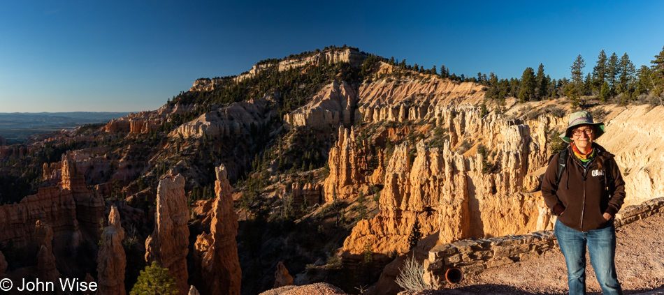
We were out early but not so early that the sun wasn’t up already. We must be getting comfortable in these years as in the past; we’ve taken a lot of pride in always being up at dawn; then again, we didn’t get to our room before 10:00 pm last night, so there was that. As I said, I wrote the previous bit when we were waiting for our tour guide, but as I’m here editing and adding to this post a week later, I find it lame that I tried to pull off getting to our room at 10:00 was a decent excuse for missing the sunrise. Heck, we used to get in at midnight and somehow still managed to drag ourselves out at 5:00 in the morning to see the first rays of sunlight. This can only be an indicator that we are growing old. Live it up, young people; this might happen to you, too.

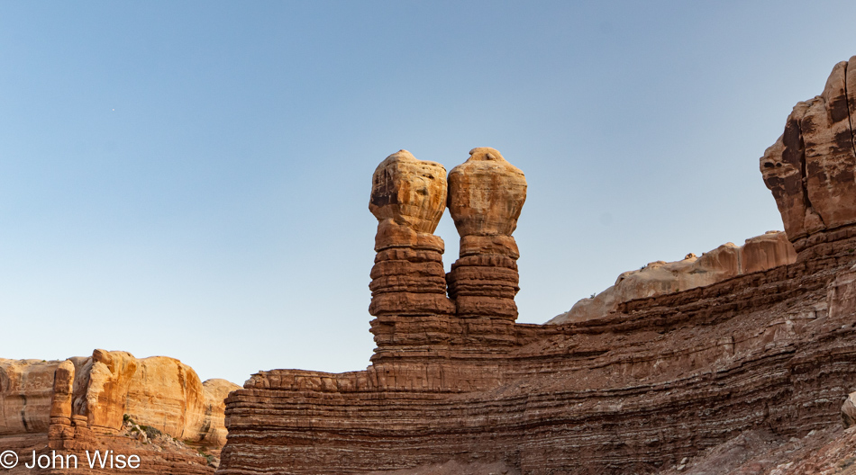
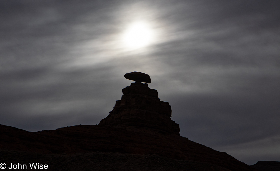
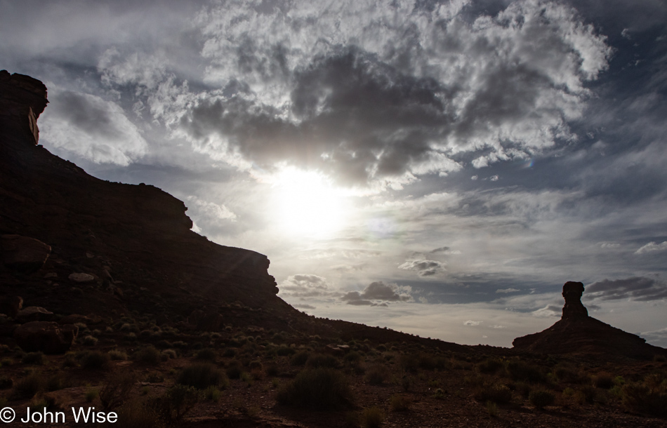
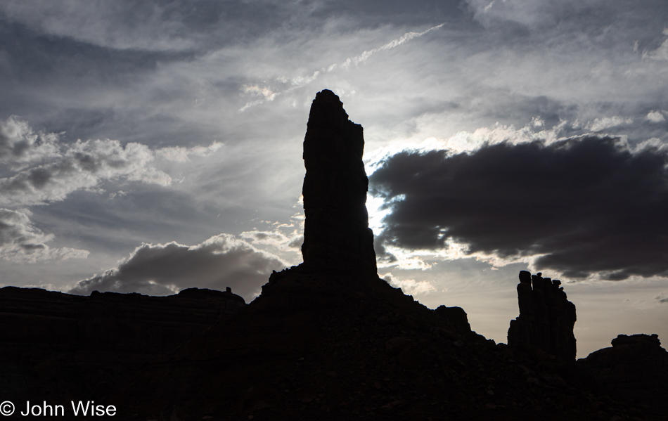
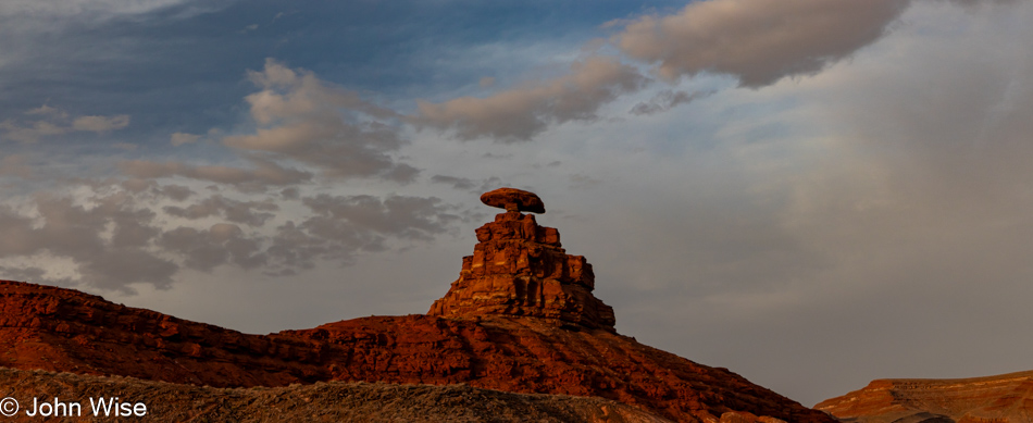
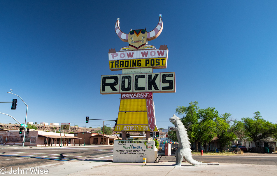
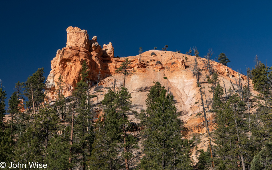
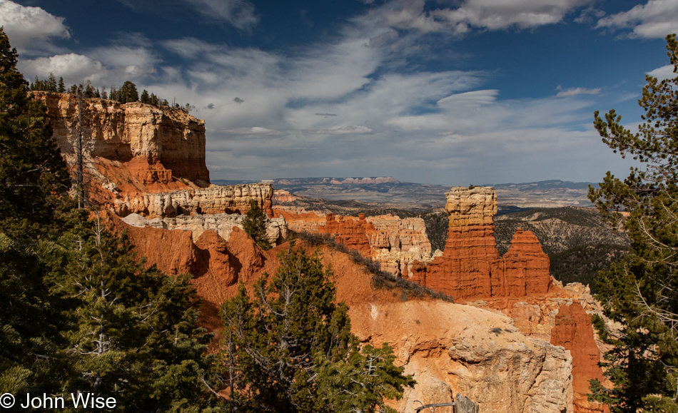
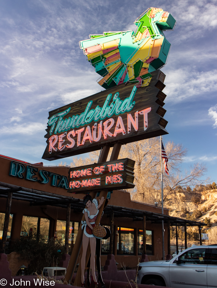
These Twin Rocks in Bluff and the Cow Canyon Trading Post across the highway are the two things that will always let me connect with my fondest memories of our previous visits. The posh trading post below these rocks caters to a wealthy clientele, but it wasn’t always that way when real people moved through the area: back then, it was a mere gift shop for mortals. Now, for example, this trading post that will not be named has seven items on their website that they offer at under $200; most everything else costs between $500 and $21,000, and don’t even think for a moment you’ll find a postcard as that’s just too declasse and something the savage proletarians might still do but not the upper crust.

I need to put that axe away, stop the grinding, and wonder why this is becoming such a frequent theme as these trips accumulate. Maybe it’s my response to the nonsense consuming America here in the middle of 2022 as the price of gas has “skyrocketed,” mass shootings are happening at the rate of two a day (seriously, there were more than 60 during May), talk of recession is scaring people, inflation is a big topic, while some even worry about the potential of nuclear conflict due to Russia invading Ukraine. It’s my opinion that most of these topics are fear-based mechanisms to move the average American deeper into their self-imprisonment while barricaded in their euphemistically titled “Man Caves.” I need to also be mindful of the fact that the changes I’m seeing didn’t happen yesterday, the last month, or the previous year; these things have been accumulating.

In any case, considering the here and now, a 1,000-mile drive in a car that gets 30mpg will cost $166 in gas for the family compared to, say, flying 500 miles to Quebec City from New York City, which would cost a family of four over $2,000. Others might lament that inflation is putting lodging out of reach; oh really an apartment in Quebec City for five nights at $650 is too exorbitant? Yet, spending nearly $100 for dinner at a restaurant for a family of four is reasonable?

What I’m getting at is that I can’t help but think that travel is being discouraged for the hoi polloi (the common people) and that someday, my wife and I will be priced out of this luxury of luxuries. And we are the lucky ones as our decision to live frugally in Phoenix has allowed us to budget about $2,000 a month for travel, but I see the writing on the wall that by the time we reach retirement in approximately ten years, we will have to come up with $4,000 to maintain our pace. A decade ago, we could get away with spending about $150 a day or $900 a month. The big joke on the American people who think they’ll be traveling in retirement is that they’ll never be able to afford it on their meager social security. Heck, even if they saved $500,000 and drew that down by $2,000 a month for a period of 20 years while combining it with their $3,000 from social security, after food, property taxes, house payment, or rent, utilities, fuel, and dependable transportation, the remaining $1,000 might allow them to get away for a weekend a month. Damn, we are idiots oblivious to the future.

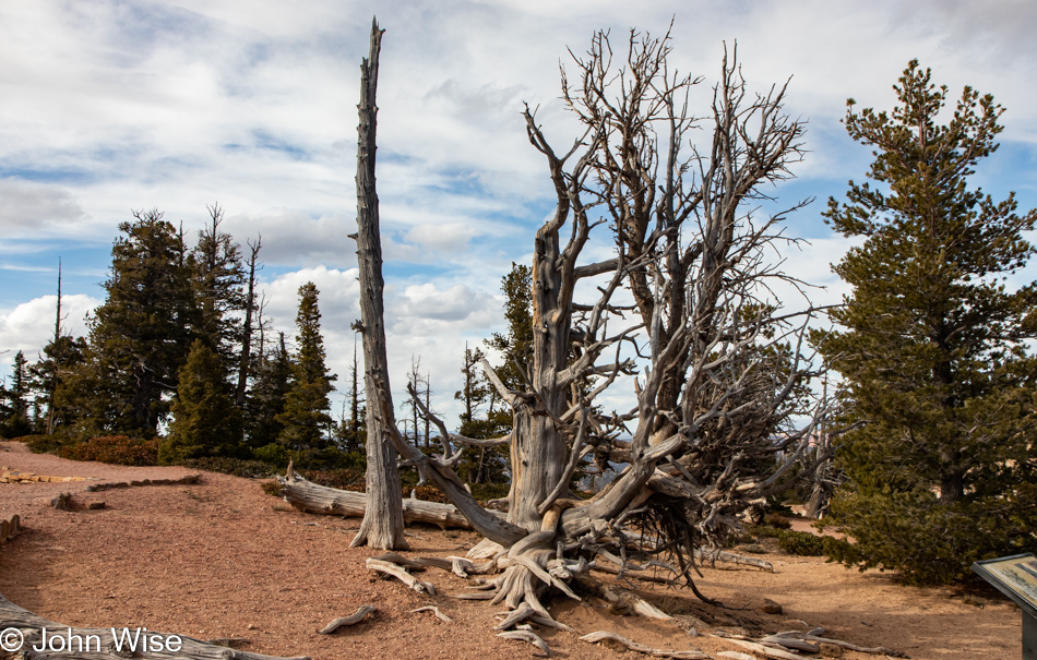
Gack, I’m such a horrible capitalist! Heck, I’m not even that, as truth be guessed, socialist blood courses through these veins. I want everyone to know some perfect corner of nature for themselves as I feel that Caroline and I planted some part of us out in the wilderness, and what’s bloomed has brought us oodles of happiness as though the sun filled us with a perpetual sense of wonder. We don’t just gaze at these places of expansive charm we unfold some intrinsically deep organ of perception that connects a kind of primordial umbilical cord into the heart of it all. We are not on the surface of a planet; we are profoundly connected to the flow of life. We don’t even breathe for ourselves; the atmosphere pumps air into our lungs so those of us in love and respect for this place of grandeur might share with others our heartfelt awareness of majesty.

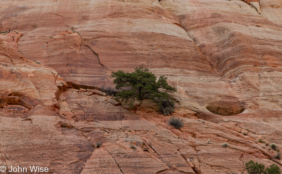
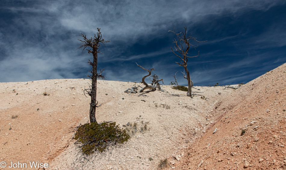
I’m not all that impressed with you, my fellow humans; you’d never hold fast to the side of a stone wall, find nourishment and life to exist on your own without the support of all of the rest of us. Yet, egos, lies, and deceptions have tricked the masses into believing in individual greatness that might only be emulated by the most foolish among us. We need each other. Oh, why didn’t I see this before? I am now old and no longer part of the breeding gene pool. I can afford to ride high on my lofty ideas as I cannot attract another mate with my rigid hostility to banality, so I sit alone like this tree, unable to move from my stone perch. Hah, you’d be wrong if you believe that because just as this tree is able to throw off its seed, I throw off these words that might at some point take root in some other unlikely place and share an idea that could change the landscape.

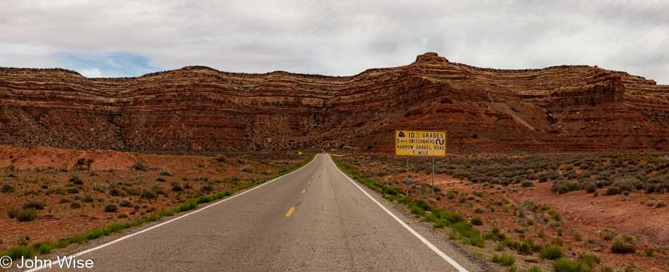
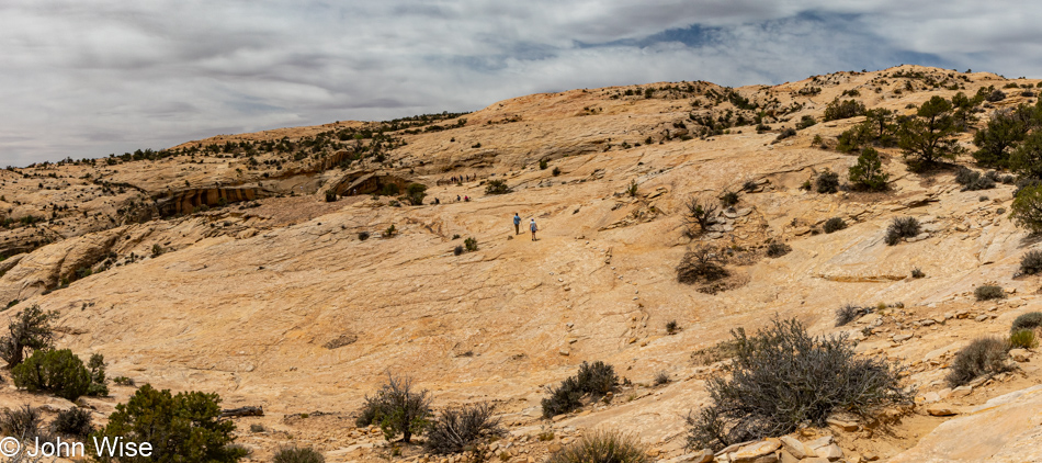
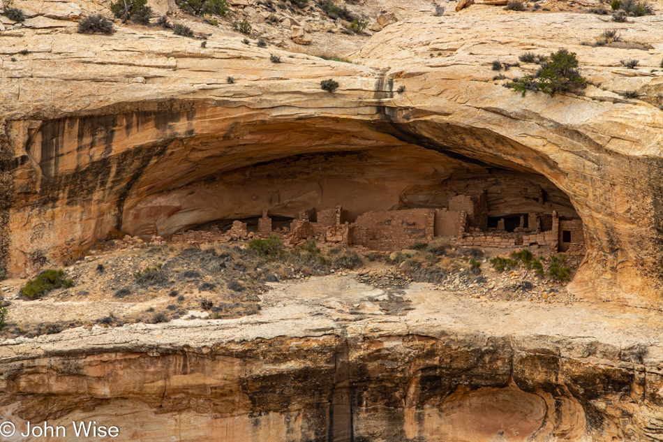
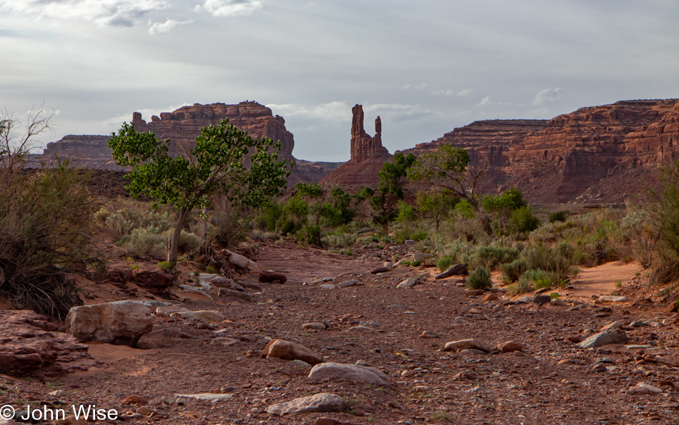
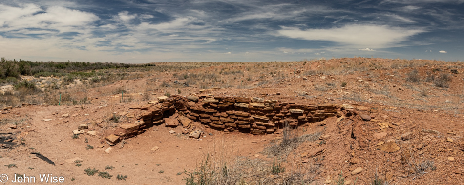
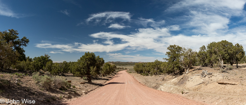
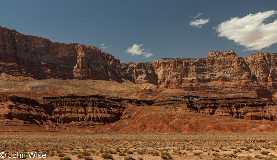
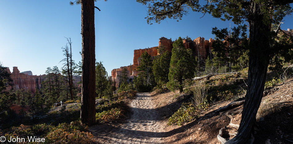
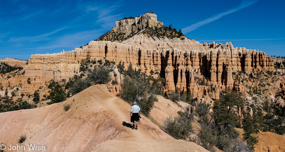
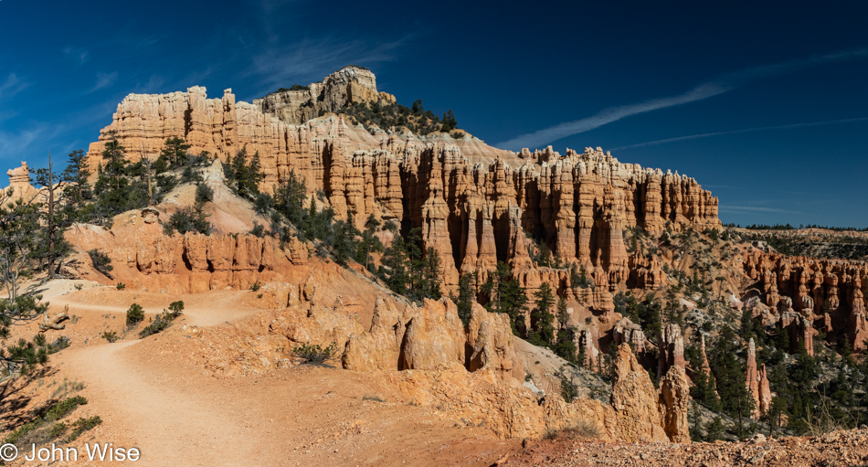
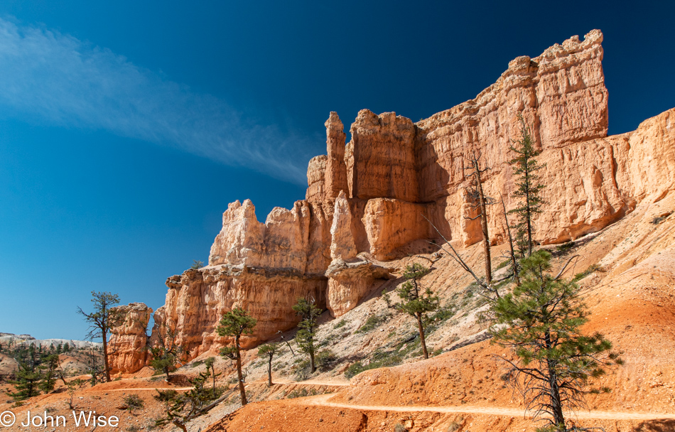
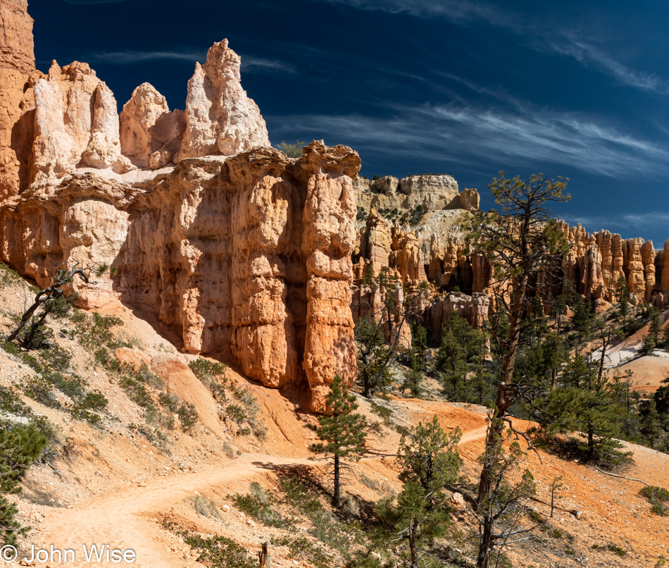
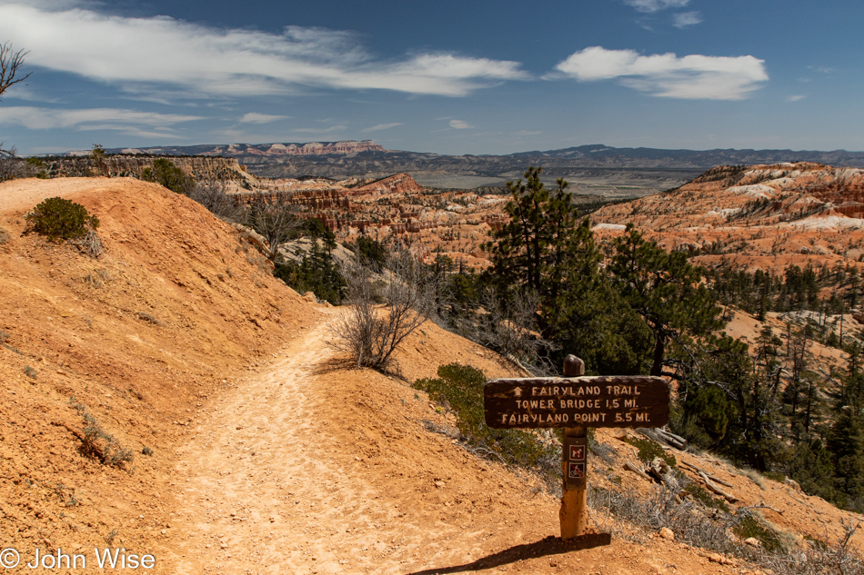
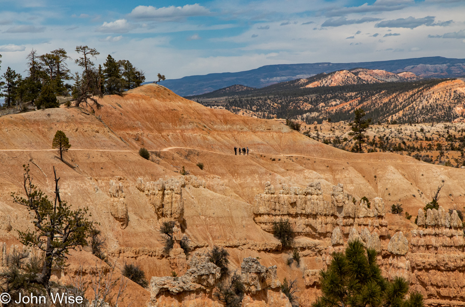
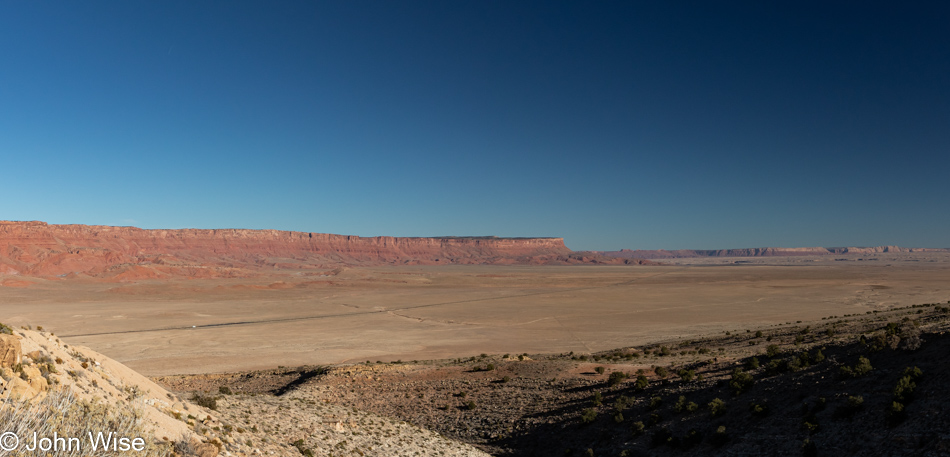
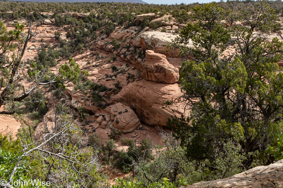
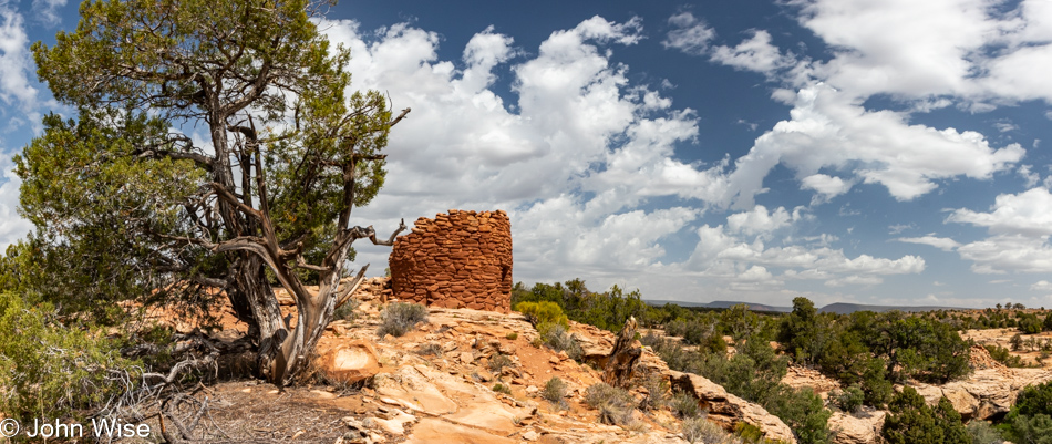
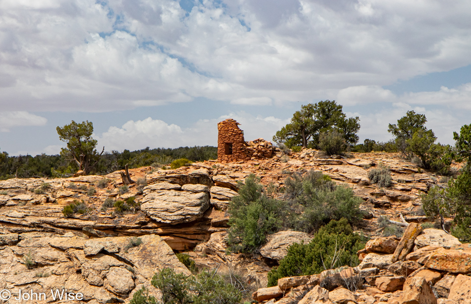
Bears Ears National Monument (which we drove into and out of yesterday) is the focus of at least the first half of today with the intention of reaching the House on Fire. In that effort, we walked along the rim trail we assumed was the right one, this being the Mule Canyon Ruins Site and all. Staying on the trail and finding a path to House on Fire was a serious challenge. It turned out that the reason was we weren’t in the right place. This has something to do with the lack of adequate signage here in Bears Ears, as this was the park designated as a monument by Barack Obama and subsequently mostly canceled by our last president before Joe Biden restored its designation and territory. Some ambiguity is still part of what’s what and where those what’s are.

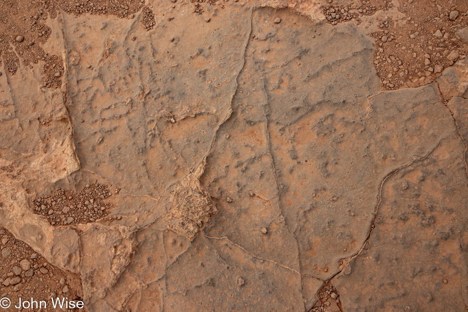
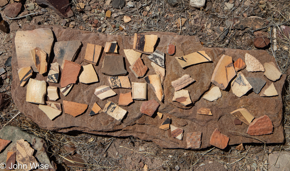
Sadly, we likely inflicted some damage on the fragile cryptobiotic soils as the “trail” was so random. Okay, it wasn’t random at all because it wasn’t even a trail but a series of mistakes by those who searched for the same thing before us, but with an interpretive panel nearby and a pit toilet, this had to be the right location, the previous right turn only said Mule Canyon while this said Mule Canyon Ruins where there are none, as far as we could find.

Later, we learned that the House on Fire is down that canyon trail titled Mule Canyon, not this rim trail featuring a ruin. House on Fire is not actually on fire but offers the appearance of being so if you arrive at exactly the right time when sunlight is reflecting off the opposite wall and onto the curved cliff above the ruin. Needless to say, we will not be seeing that during this visit as the window of opportunity has closed, and the house is no longer on fire.

After this great hike, we did actually catch sight of the House on Fire across the canyon and down below. This is a horrible photo of that site, but hey, it’s all I got. If you zoom in on the broken boulder near the center of the photo, you might recognize a few people standing near it, but sadly, not us.

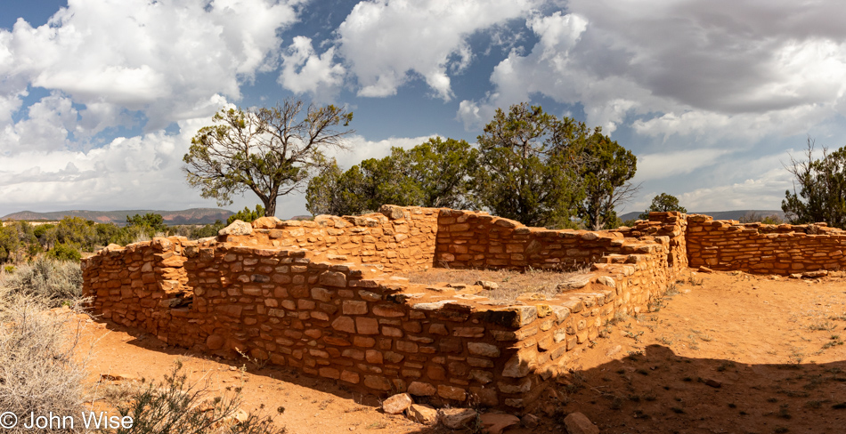
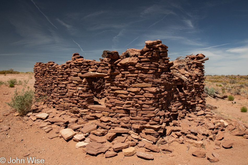
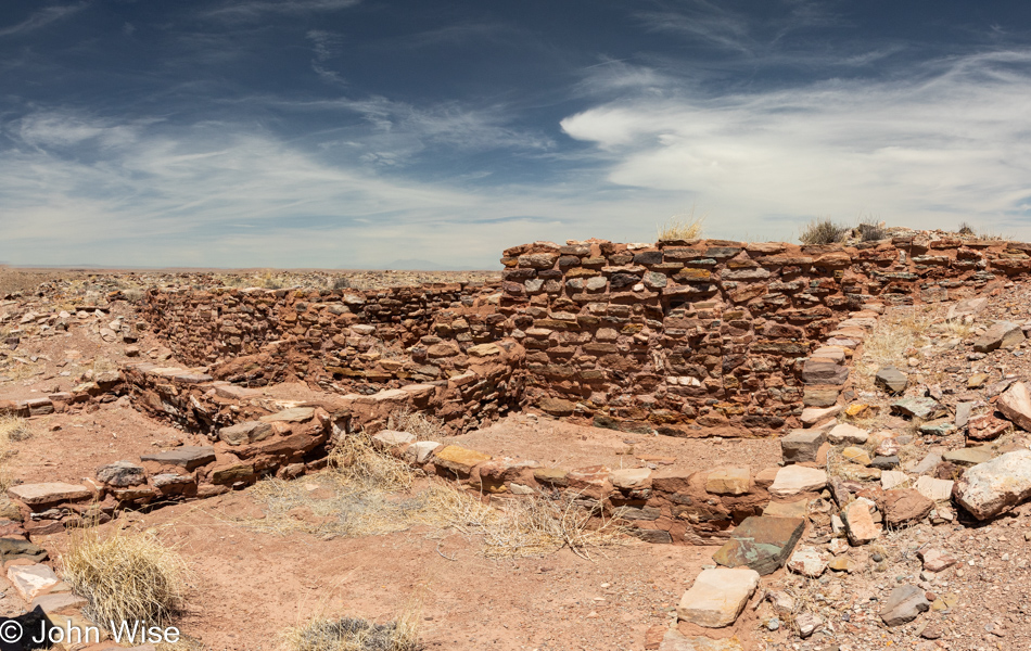
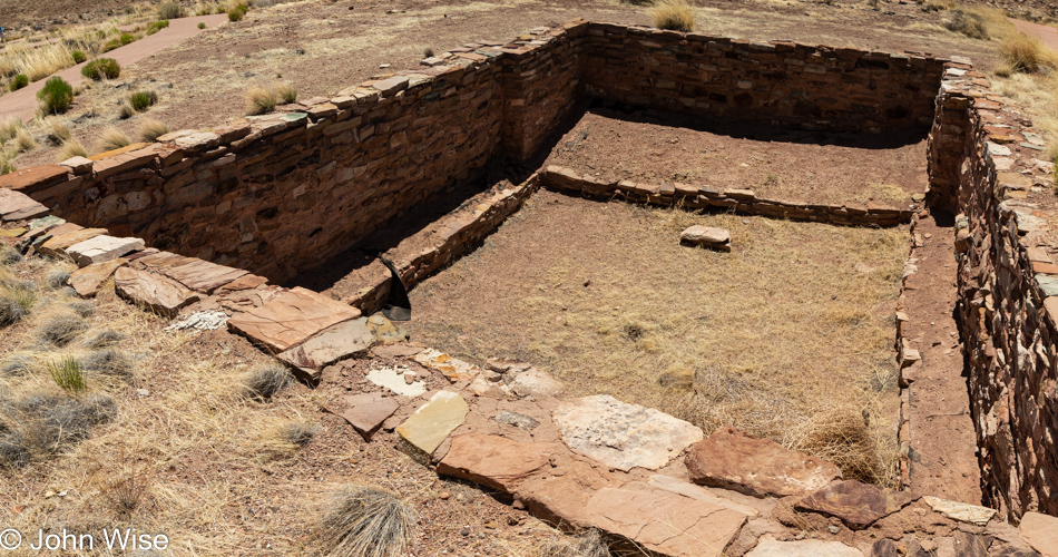
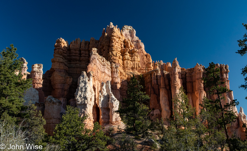
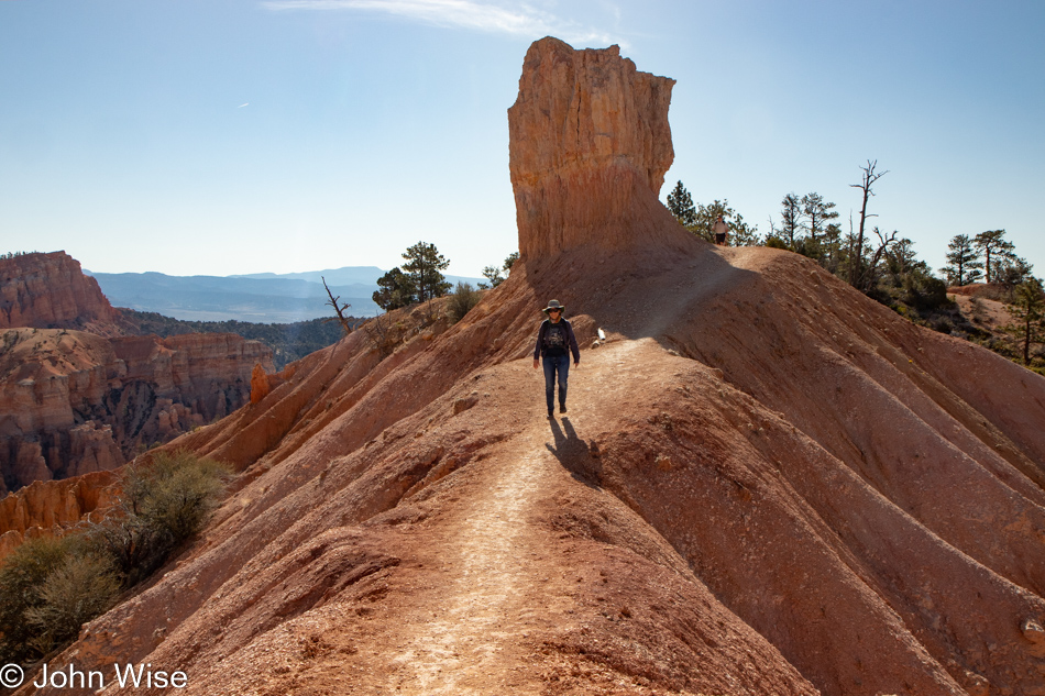
Over at the interpretive sign (which we had ignored on arrival), we now understood that Mule Canyon Ruin is this structure right here. We couldn’t see it nor the kiva to its right from the parking lot, hence not finding it. Defeated (just kidding, we are never defeated), we took off looking for the unmarked turnoff that promised to deliver us to the Cave Towers.

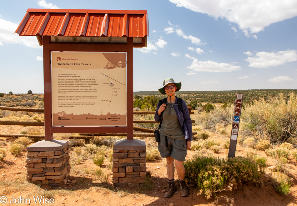
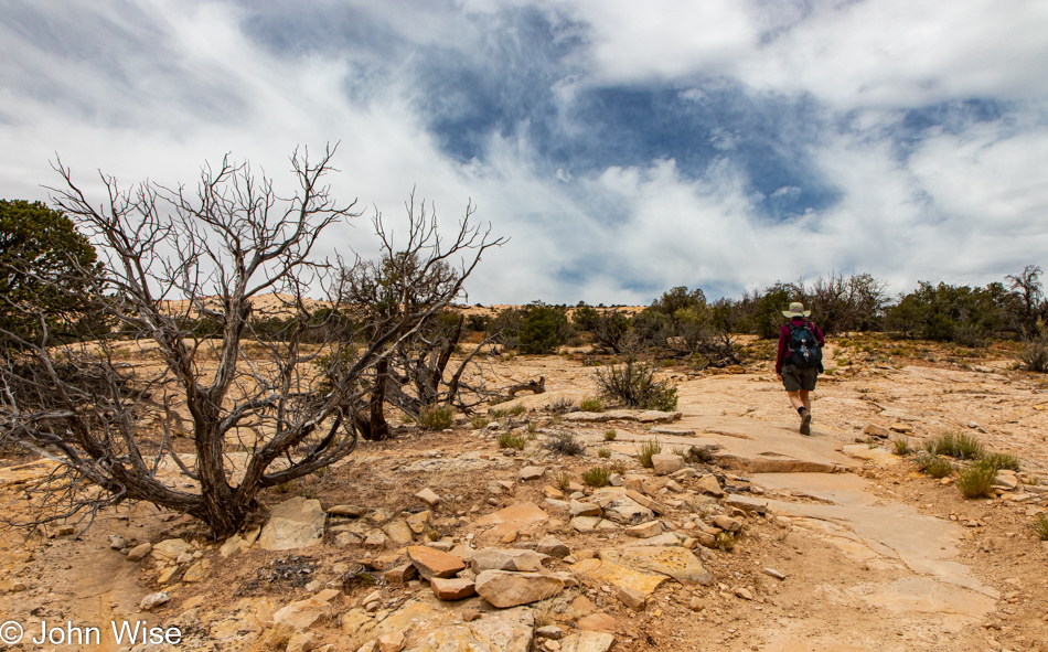
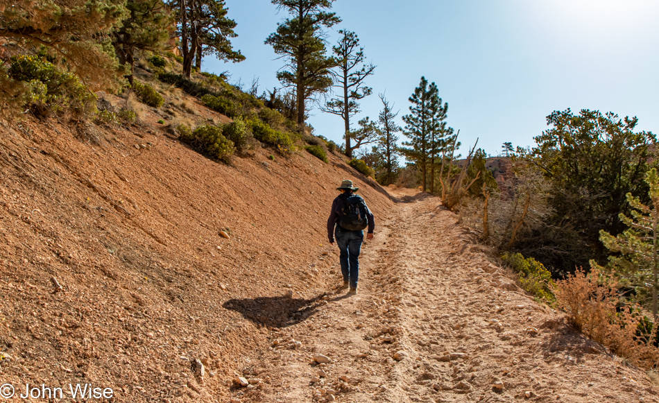
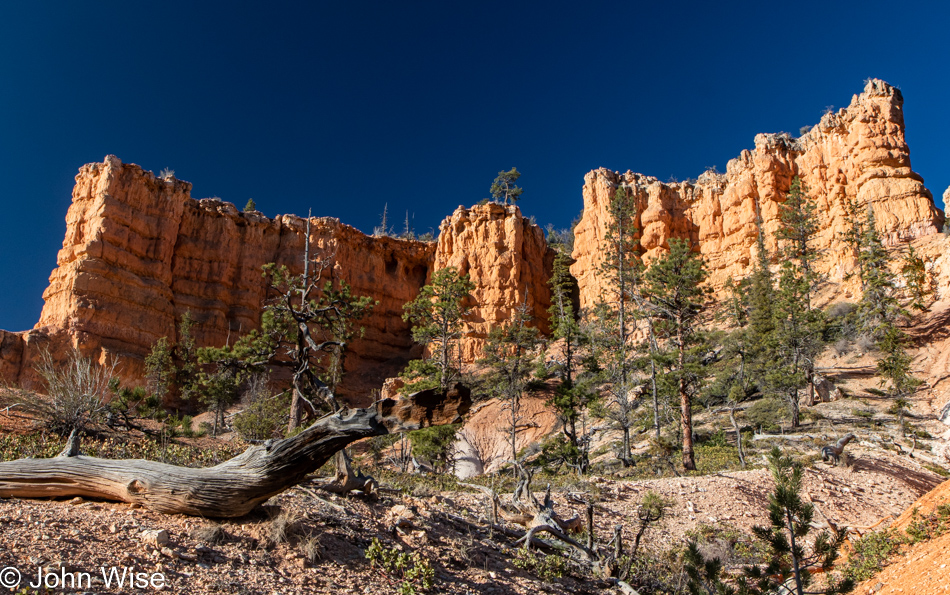
Just off the road and through a gate was a sandy, bumpy road we were too chicken to drive as it appeared that it wouldn’t have played well with the bottom of our car and merely two wheels of traction. Good thing the walk wasn’t very long to the beginning of the trailhead Caroline is standing at.

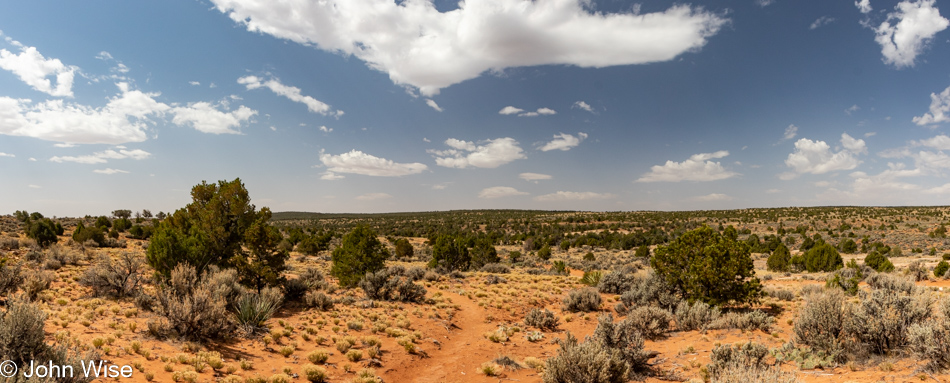
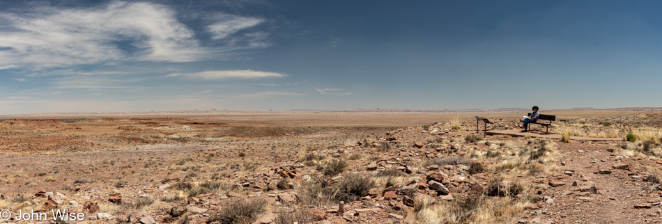
It was out here in this vast land that we got lost forever. We are out there right now wandering aimlessly and carefree because what’s better than communion with the infinite when your god is the universe of nature? Natural sensuality, hot, cold, wet or dry, sunny, dark, dangerous, sometimes benign, holding all the potential for surprise, enlightenment, fun, and love, these things feed our sense of the real. Look at it all spelled out in the clouds, bushes, hills, and sand. Stop a moment and try to remember the last time your feet trudged through the sand and you tripped over a pebble because your focus was on a cloud that reminded you of something or other.

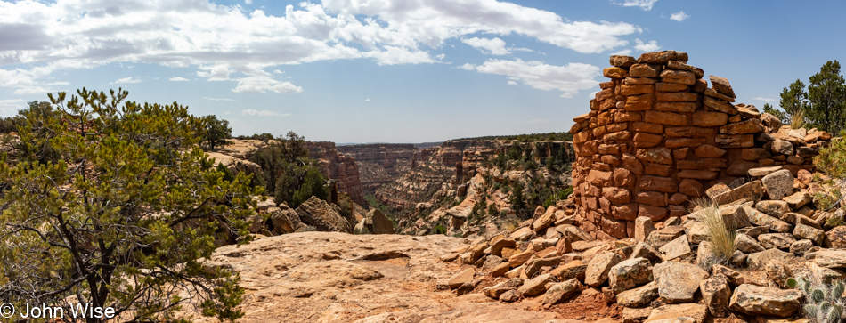
After exhausting the possibility of returning to our car, we took up residence where an Anasazi structure once stood. Starting with just a pile of rocks, we created ourselves a home from the ruin. If you’ve been looking for us, you’ll find us here, wherever here is. We’ve given up the search for meaning outside of perfection, as it seems that our larger society is intent on exploring the madness of not being able to cope with nothingness. Out here, the space between is full of everythingness, and where gaps exist, our love and appreciation fill those voids.

We continued work on our growing tower home, making great progress with the understanding that monsoons will arrive with the summer. Protection from those tempests was required as our naked skin couldn’t fully shield us out here in the big nowhere, though we seem to have been effective in throwing off the banality that was just under our skin from living amongst all of you.

I can finally admit that we didn’t get lost by accident; we made an intentional move to escape the inanity of all that our culture stuffed us full of, as though we were some kind of sacrificial turkeys destined to be eaten by those who feast on the poison of stupidity. Our modern-day Dracula myth works this way: fatten the masses on intellectual tripe and then milk those fantastic breasts that money is excreted from. Titties and cash are the elixirs of happiness for the ruling class.

Now that we live carefree, naked, without money or hope of returning to your world, I beg of you, do not try to rescue us as we have rescued ourselves from drudgery and will find happiness on our own. As I grow to forget you all, I will remove a stone at a time from our new home until the day we die when we’ll have left the earth without leaving a trace that these new ancient ones with dreams had once been among you. Your existence does not deserve dreams as you wallow in the sorrow of failure. Hey Caroline, do you think we can get Grubhub to deliver us some coffee from Starbucks out here?

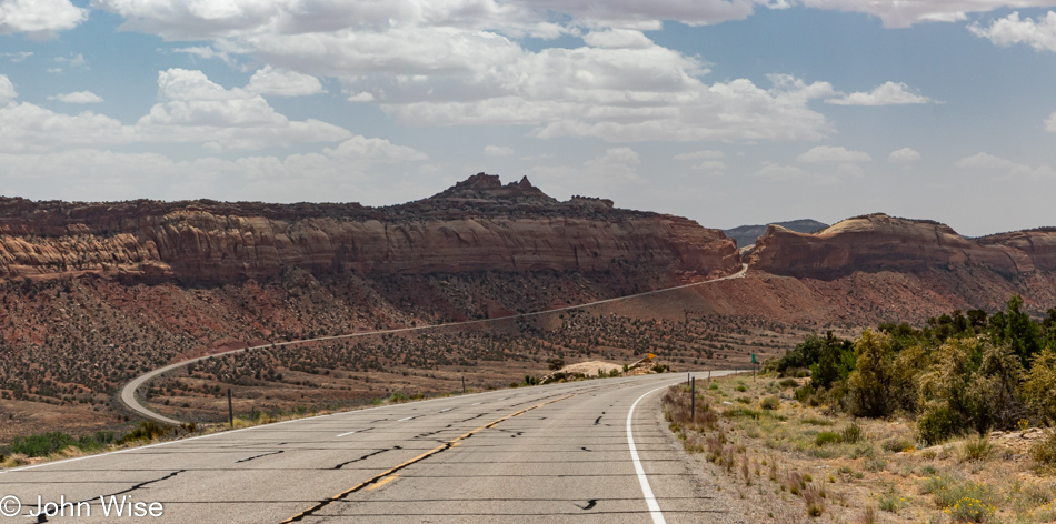
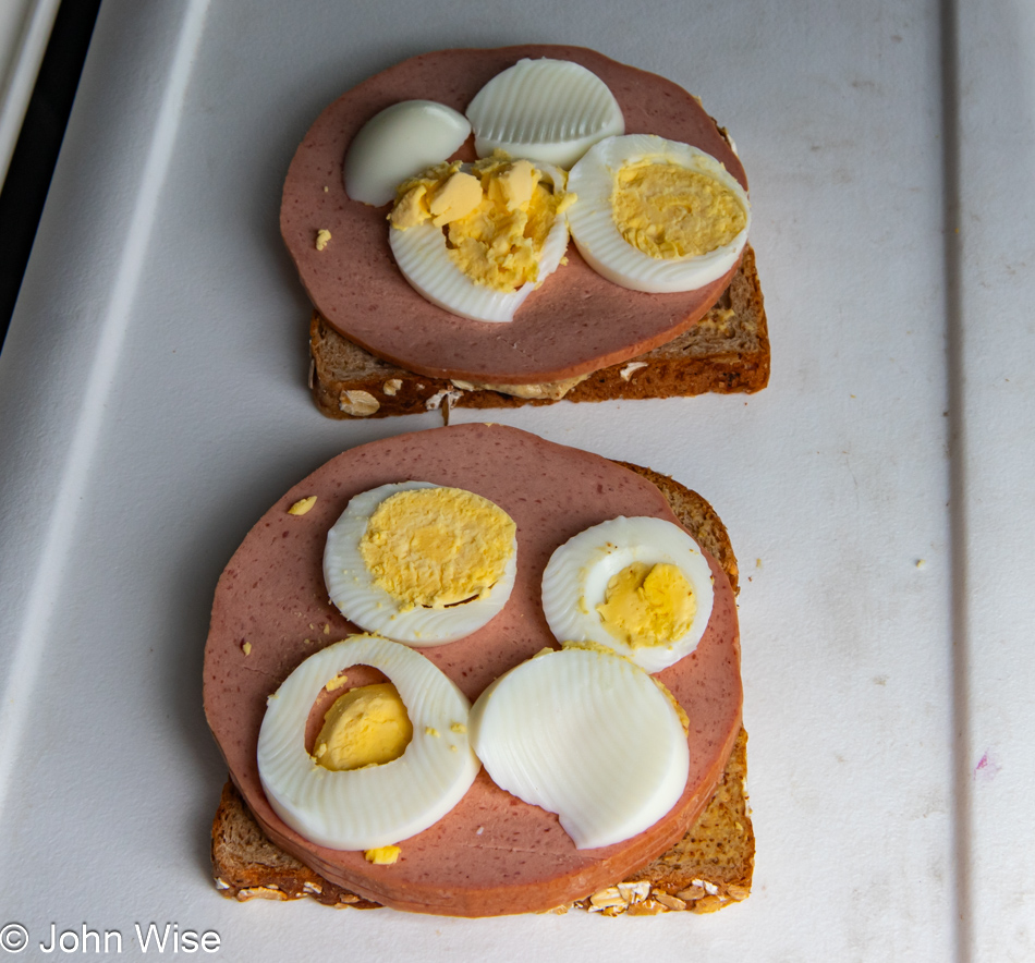
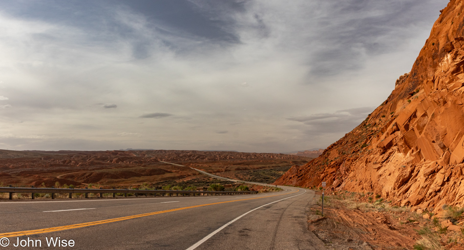
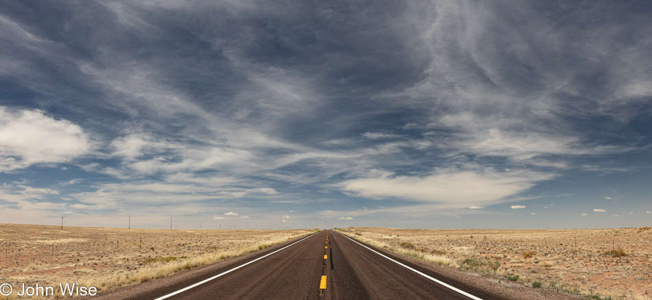
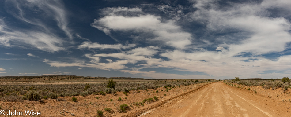
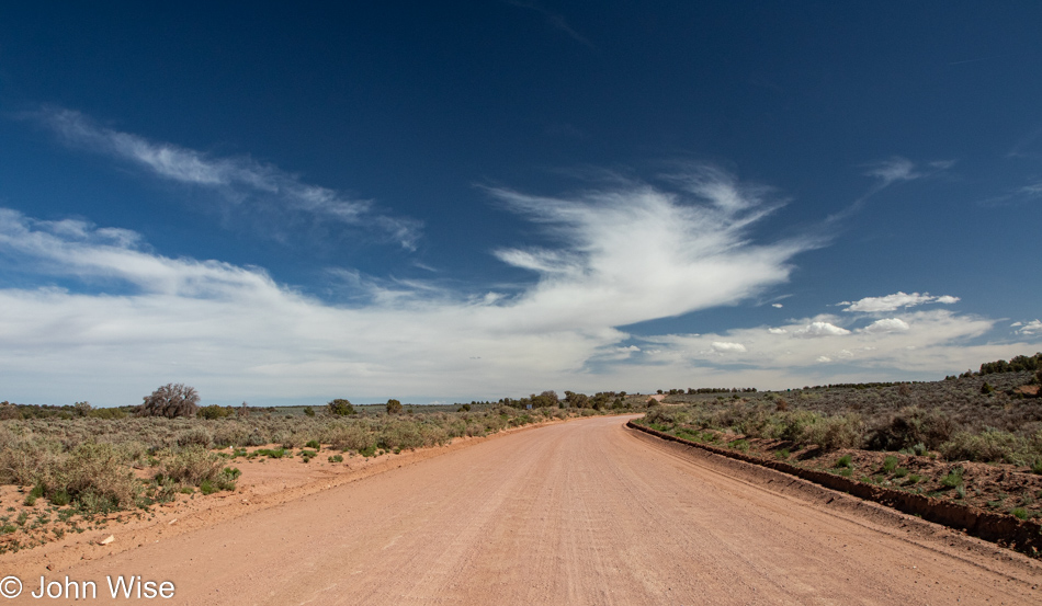
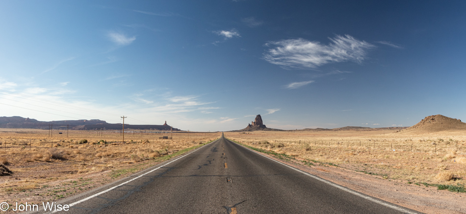
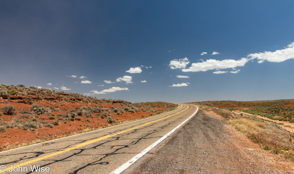
Today, we’ll drive over 153 miles of paved roads that, on average, cost our governments about $635,000 per mile to build. Caroline and I are truly experiential millionaires as we trek effortlessly over these $97,155,000 worth of roads in a car that has over 100 years of engineering behind it. We travel with music, phone service, and even an ice chest, allowing us to have fresh fruit, meat, hard-boiled eggs, and whatever else we might want to drag along in our air-conditioned car. The gasoline for this adventure today, even if it were $10 a gallon, will set us back $33, but in reality, at $5.39 a gallon, we only have to pay $17.92 for this entire day of crazy exploration. But wait, there’s more; what if I told you that the state of Utah would also supply you with picnic tables so you could just pull over and feast? Still not enough for your pittance of tax contributions? Just ahead, you’ll find places to stay and people preparing hot food and medicine should you need it, and you can get there from the comfort of your car, traveling at 60 miles an hour over the surface of a planet in space. How about we stop complaining about taxes and the price of gas?

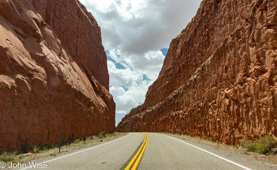
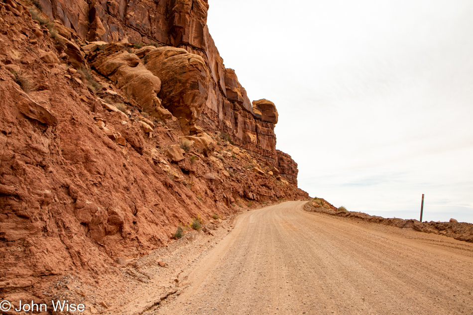
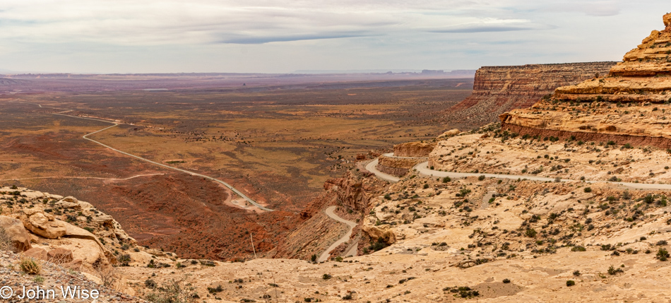
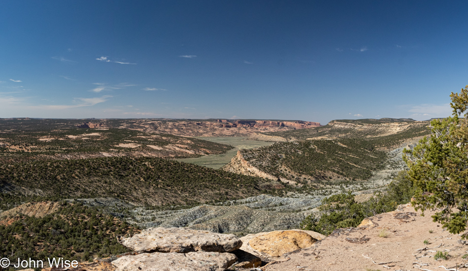
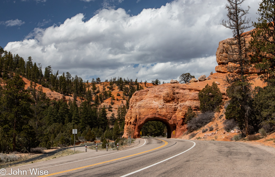
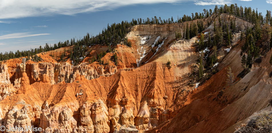
Just wow, who the heck had the great idea to slice down through a mountain of stone so we could easily drive through this space instead of driving off the cliff? Look at the photo above this one; the road that climbs the incline is exactly where we are right now. As for the signs that tell drivers, “No Stopping or Parking” and warnings of falling rocks, they are heeded as the danger is apparent and so I take my photo through the windshield while trying to drive especially slowly.

We are heading east before turning south to avoid being late for a scheduled 5:00 p.m. meeting.

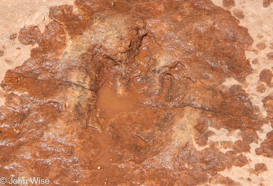
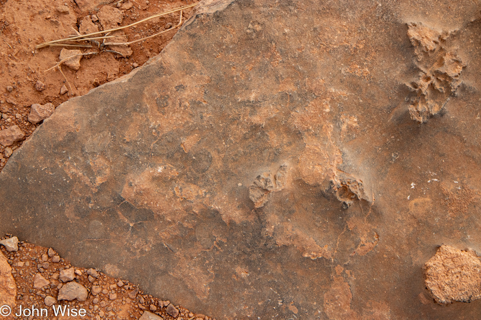
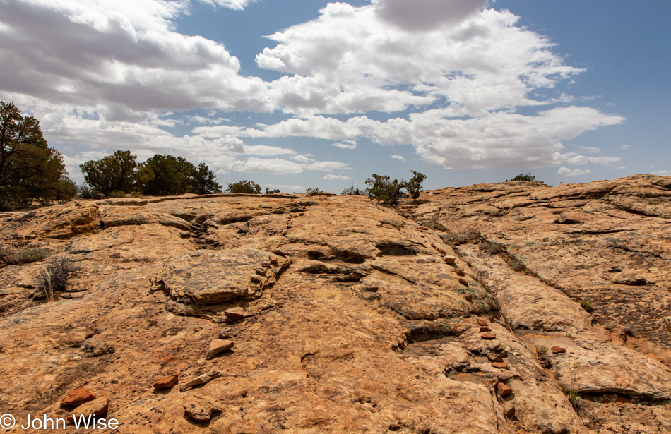
But first, we’ll have to stop for just one more thing. A short hike to a one-hundred-sixty-million-year-old dinosaur track left by a meat-eating, bipedal, theropod beast that is long extinct. Photographing this mid-day was no easy task as shadows were nowhere to be found. I did take a photo with Caroline’s hand next to the impression, but it didn’t turn out as well as this one. The track is larger than her hand.

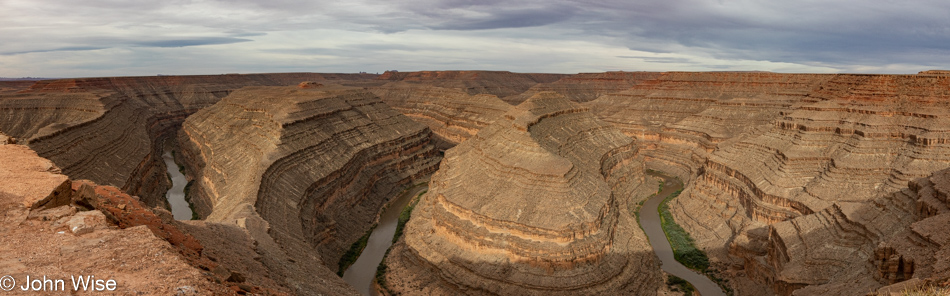
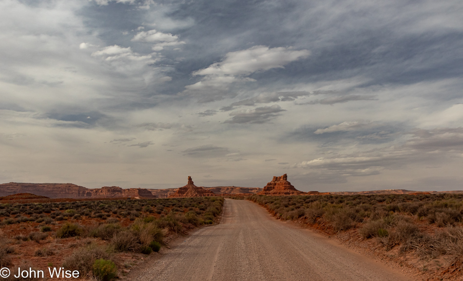
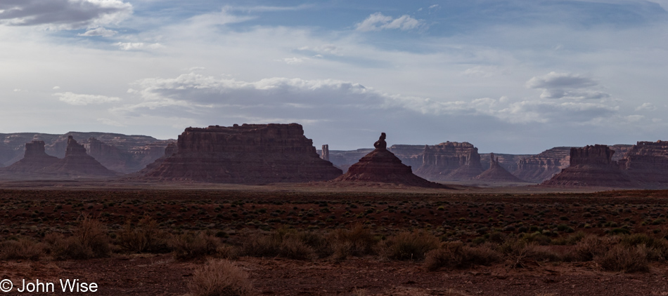
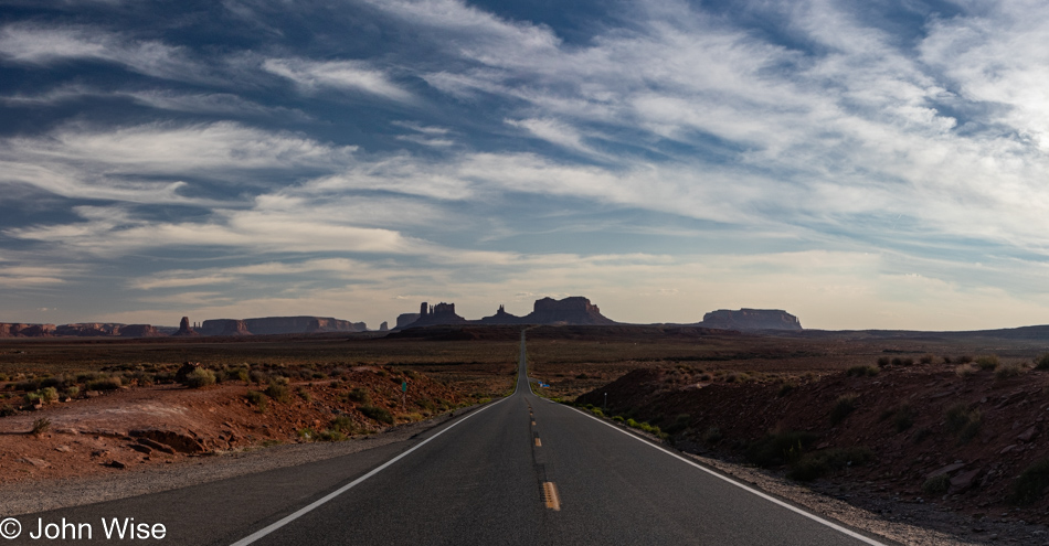
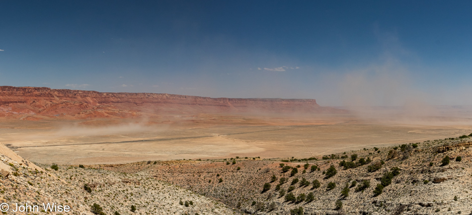
For your information, we are in Butler Wash, which runs for 23 miles north and south. There are many things to explore, including the Wolfman petroglyph panel we would have liked hiking out to, but the threat of rain (hard to believe, but we actually caught some sprinkles at the trailhead) and our need to be punctual for what comes next dictated that we’d have to keep it for another time. After heavy clouds appeared on the horizon and started moving away, they were replaced by increasingly strong winds.

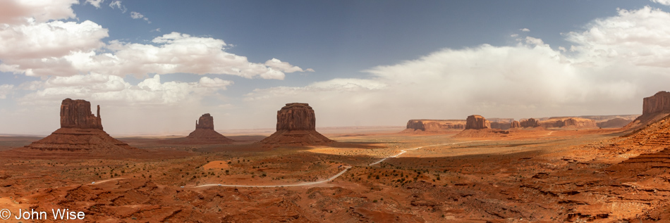
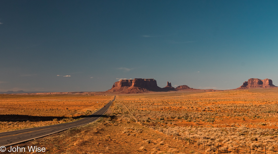
Monument Valley Navajo Tribal Park is what was on the itinerary.

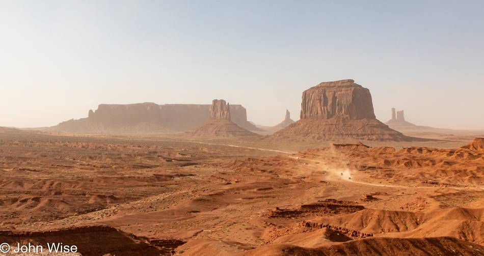
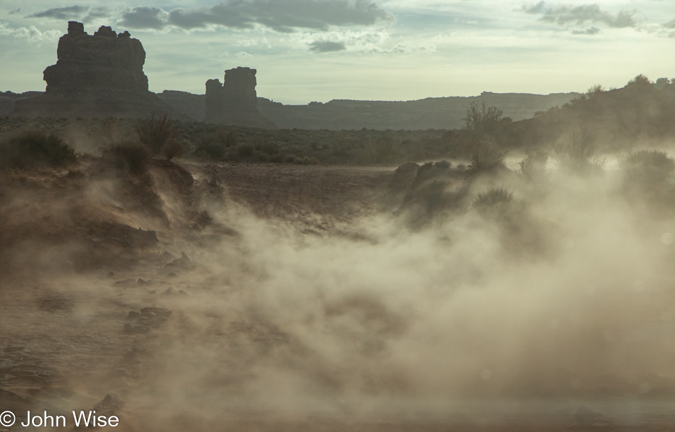
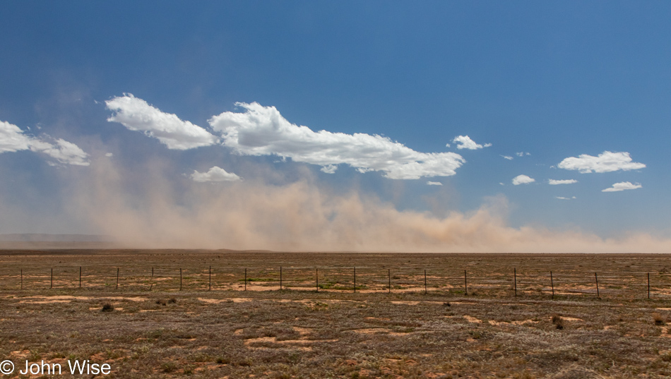
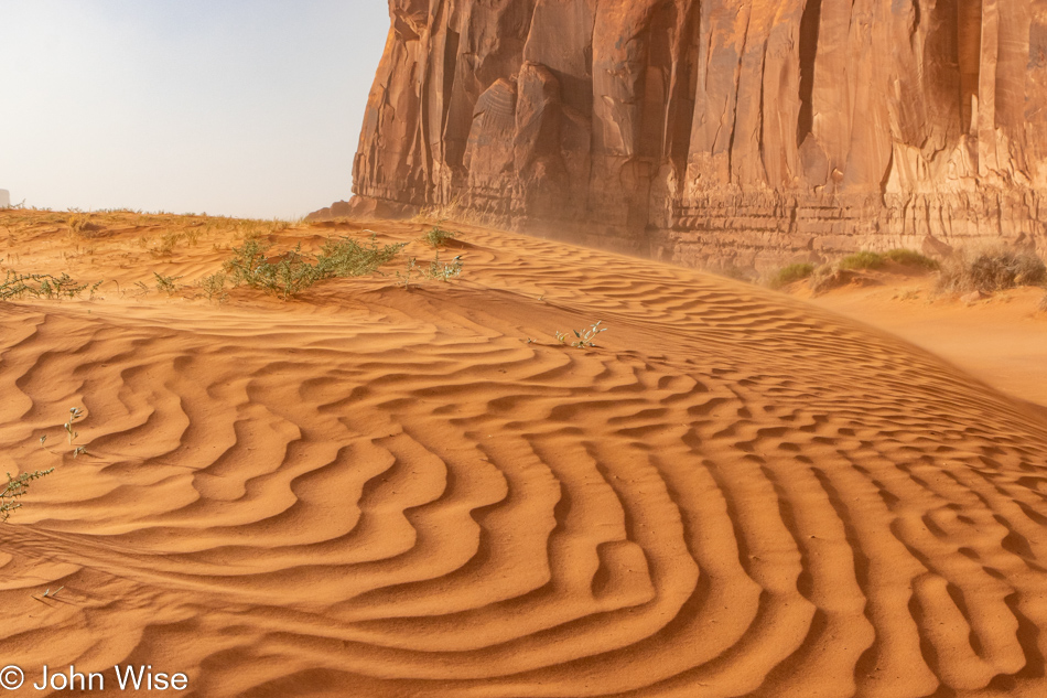
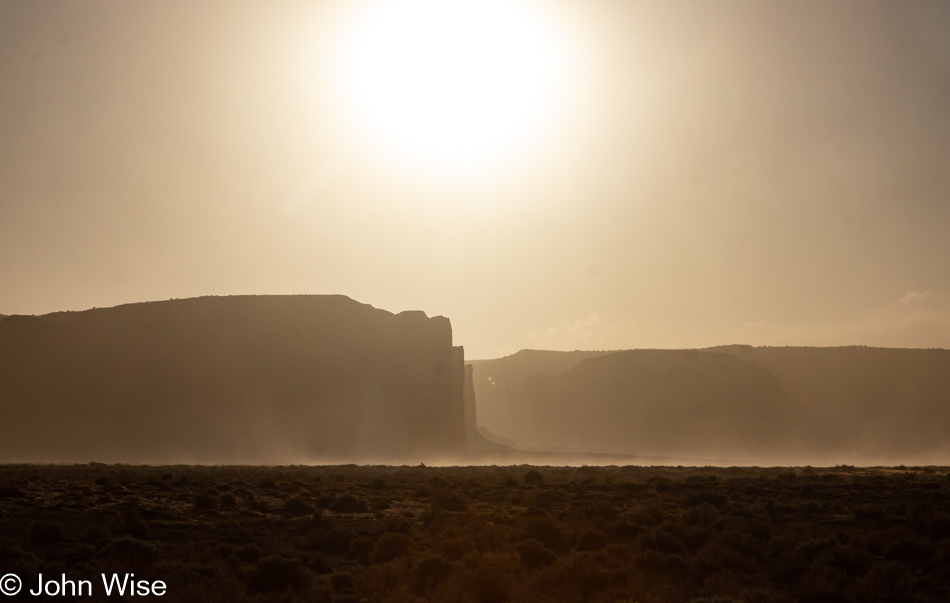
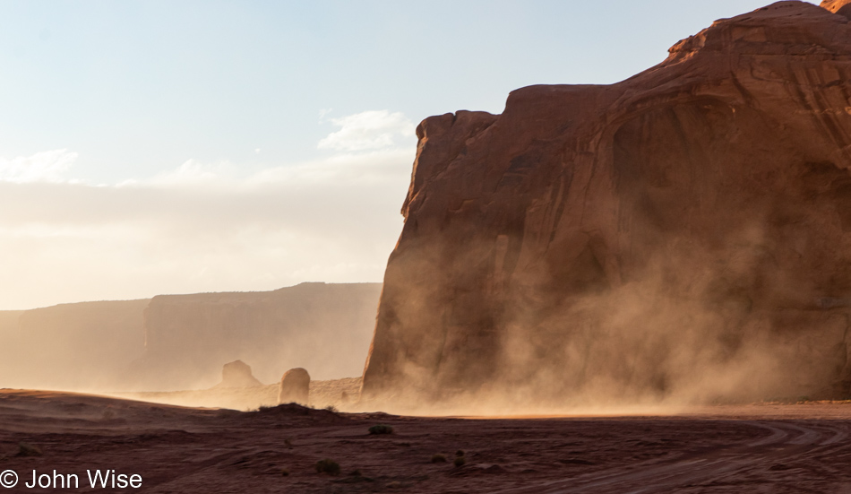
This is where we were to meet up with Cody, who I mentioned at the top of this post; he’ll be doing the rest of the driving on this day. By now, with a ton of sand tossed aloft, we’ll have to deal with limited visibility, a camera that is being impregnated with fine red dust, and expectations of red boogers. Continuing COVID rules up here on Navajo lands demand that we wear masks while in buildings; due to the dust storm, we happily wear our masks for the majority of the afternoon outside to avoid that potential booger problem I referred to.

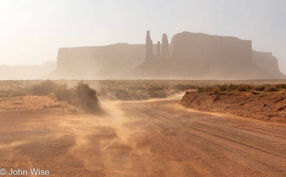
Look to our photos of the next morning for a comparison of just how much dust is in the air at this moment.

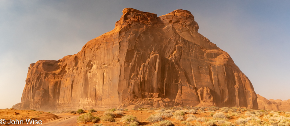
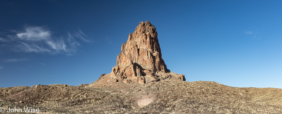
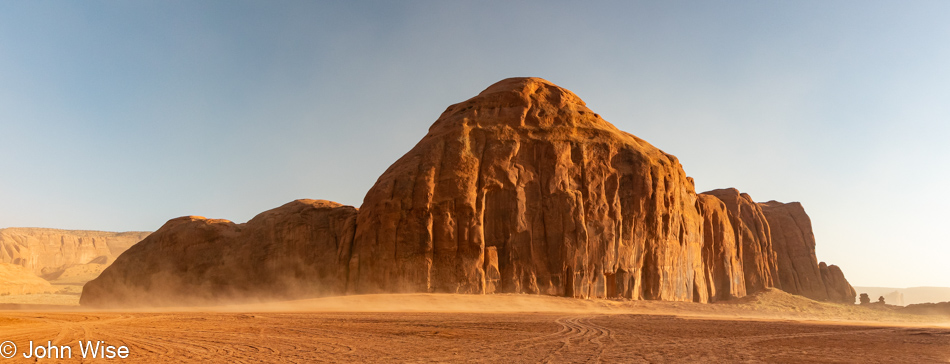
It should be obvious that this butte is named after an Indian chief; just look for it.

A benefit of our guided tour is that it leaves the main trail through the park and brings us to locations not otherwise seen by mortals attempting to damage their own cars. Being out here, there’s so much to see that it’s easy to be distracted by the monuments, forgetting to see the little things.

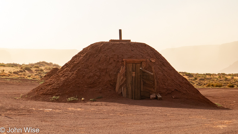
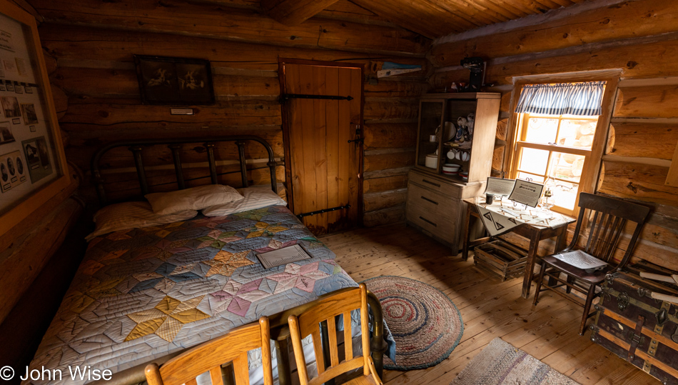
Our tour is about something more than taking the path less traveled; we’ll be sleeping overnight here, right in this exact hogan, as a matter of fact. But we have a lot more to see and do before we unload our gear and lay down for the night.

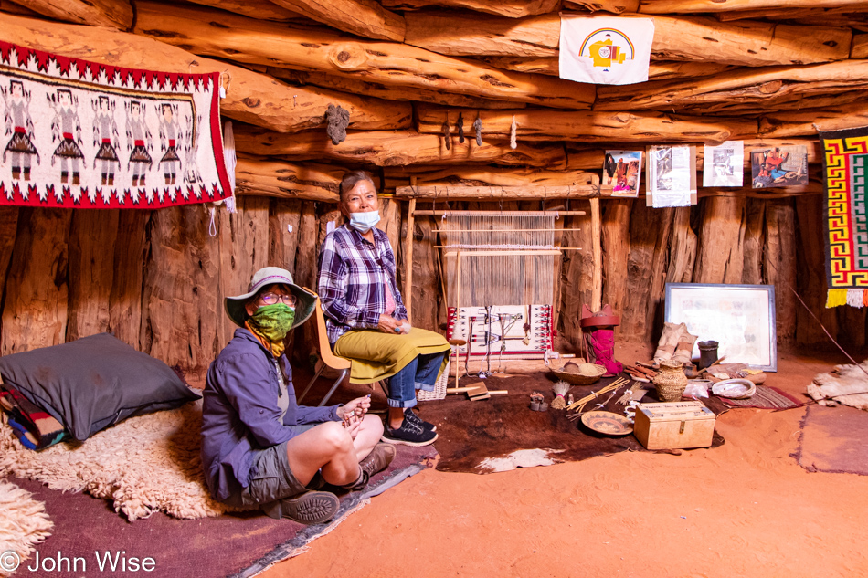
Maybe you think this is the inside of the hogan we’ll be sleeping in? You’d be wrong as this one is adjacent to ours. The woman sitting next to Caroline is Effie Yazzie, daughter of Susie Yazzie, whom we met on our first overnight in a hogan. She sadly passed away nine years ago. Little did we know all those years ago that we were effectively in the presence of royalty, a matriarch, an occasional actress, and partly responsible for 73 descendants? I have a photograph of Susie Yazzie on that post from March 2008, which you can see by clicking over to this post.

While it’s a bit dark, you might be able to see the profile of George Washington here (looking left). We’ll see more than a few holes in the sandstone towering above us, such as here at Big Hogan. Look again; maybe you see an Iroquois Warrior, or is it a rabbit?

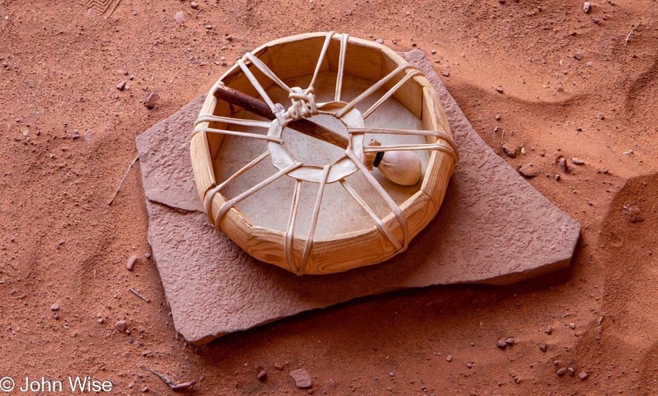
Cody offered us a song in the Big Hogan and requested that we not share it on social media, so in respect of that, I offer you the drum he played.

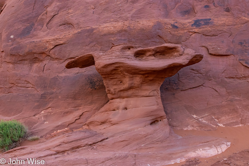
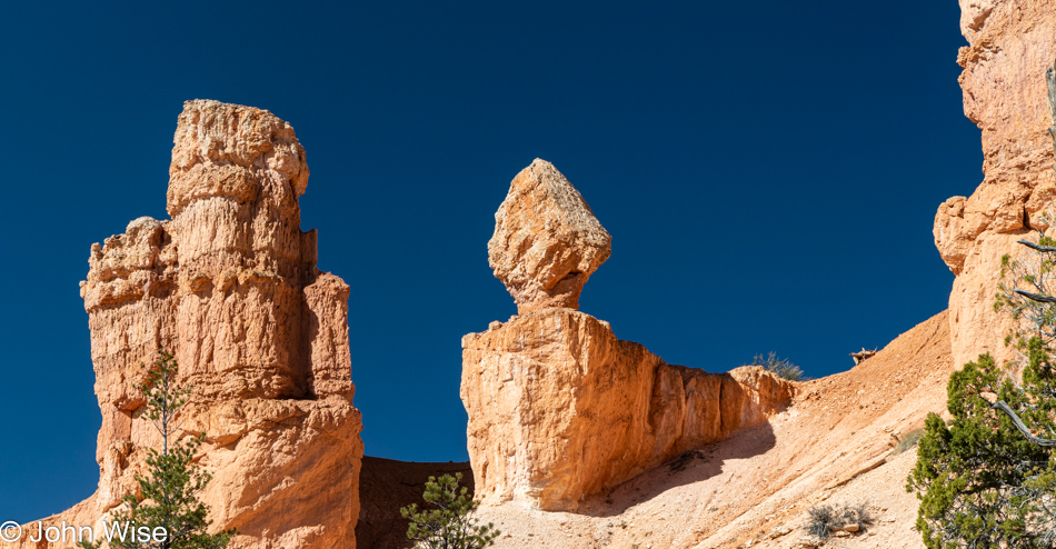
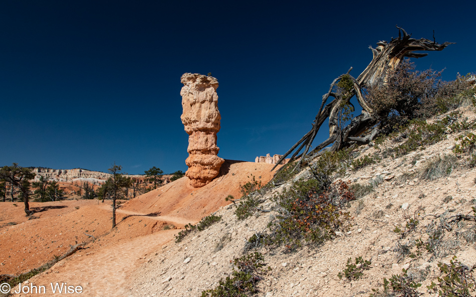
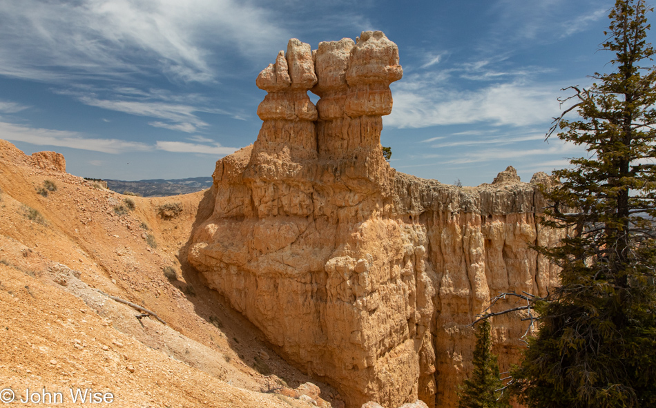
I have christened this unnamed feature, the Cobbler’s Anvil.

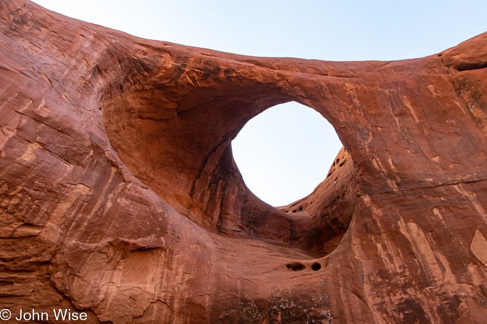
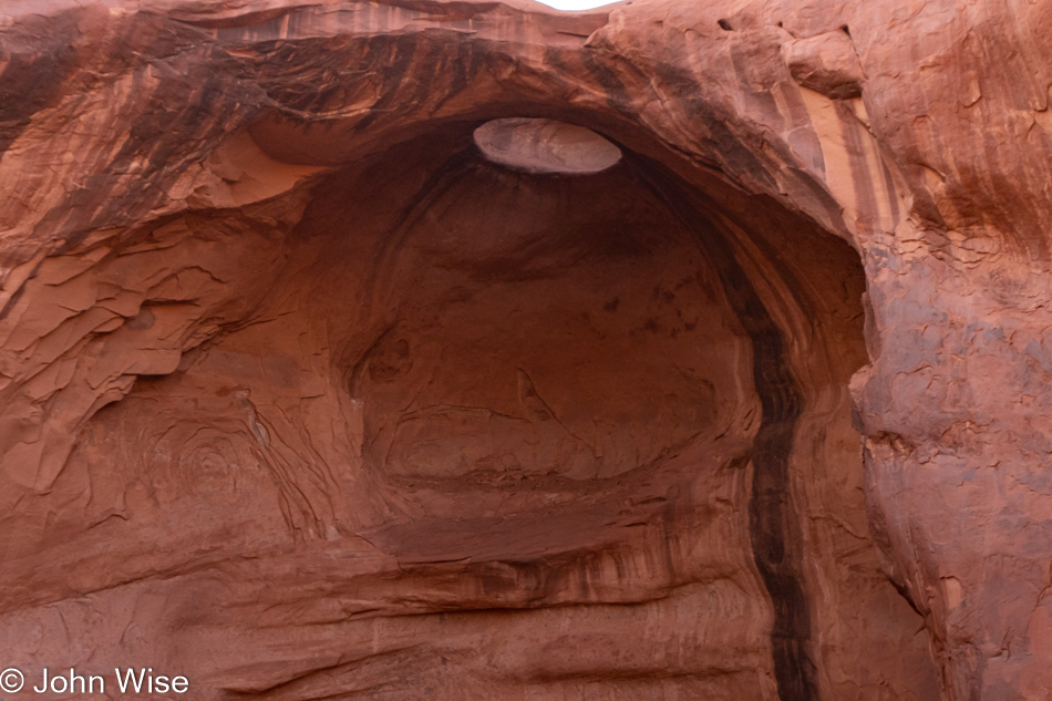
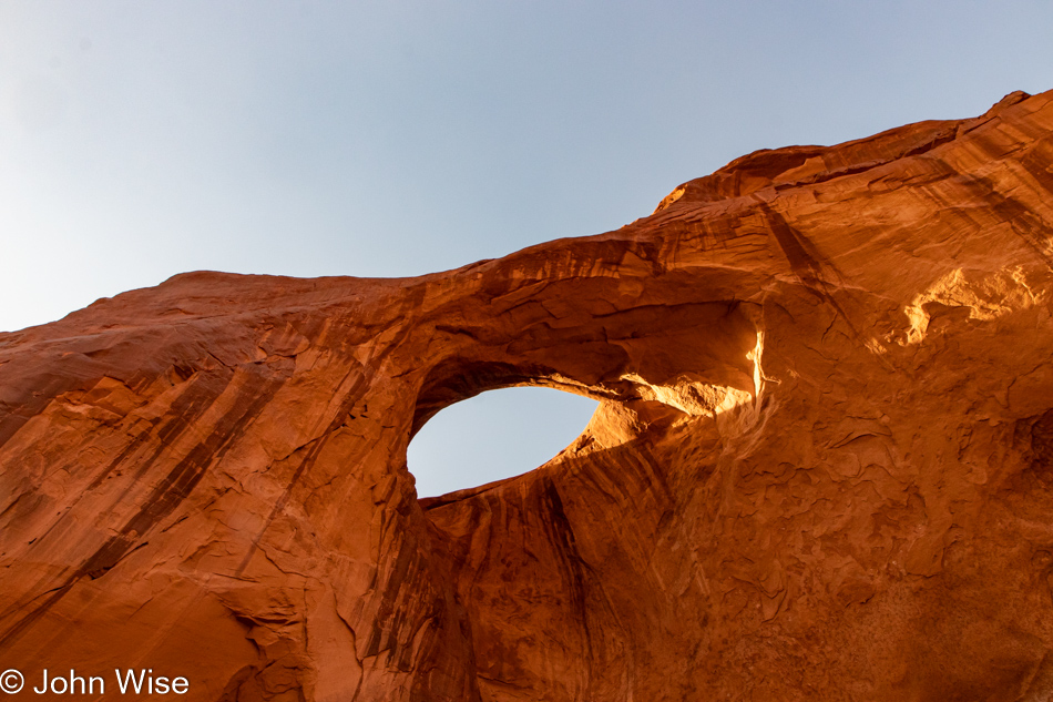
The Eye of the Needle was the next hole/arch/natural bridge we visited. Hmmm, this is becoming a “This, then that” list of things, and there’s no fun in that.

Here’s the deal: it’s June 6th when I’m writing this part of the post. I’m midway through a five-day fast, and in four days, we will head up to Winslow, Arizona, for the next step in our journey. I’ve written 2,800 words so far for this post with 42 images, and I’m still facing the need to write tomorrow’s post about Mystery Valley featuring 43 incredible photos that should also include some inspired words. This process is a formidable one as I’m intent on blogging each of our many trips this year while not falling behind, but there are other things in life that also require tending to.

We alone have been afforded this opportunity to peer through black gates into the warm taupe sky to see Earth’s past carried on the wind illuminated by the sun. The ancient dust rains down after being jettisoned from its resting place, some of it will travel with us to places beyond Monument Valley, while the majority of it will find a new home right here on the desert floor. Fine sand is in our teeth, occasionally in our eyes; it’s accumulating in our ears and hair. We breathe it, and we’ll be eating some small amount when dinner comes around. We are fortunate to be on hand for this slow-motion reorganization of our planet, where we can see for ourselves in real-time the shift of matter that ultimately breaks down and changes everything.

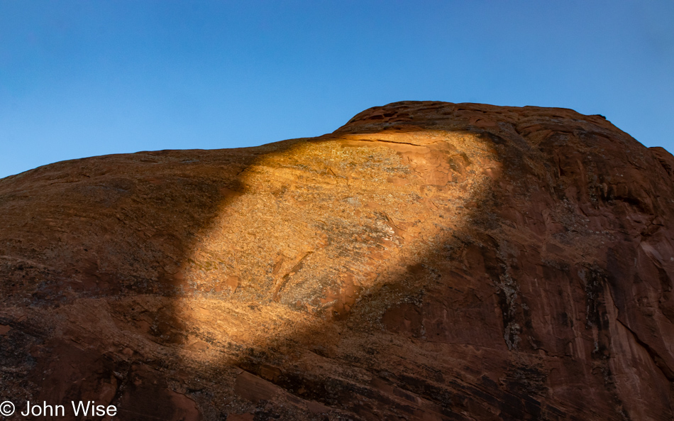
Stand below the giant Eye of the Sun and look into its depths; what do you find? Do you see the streaks of tears staining its cheek? It’s incomprehensible that we should be offered these opportunities to gaze into grandeur and not be forever transformed, but that’s the reality the sun and universe must contend with, and so they cry. If there were gods, they too would shed tears at the simplicity of a creature capable of such exquisite passions squandering these rare moments.

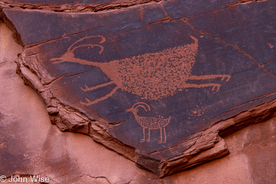
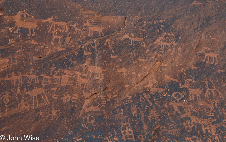
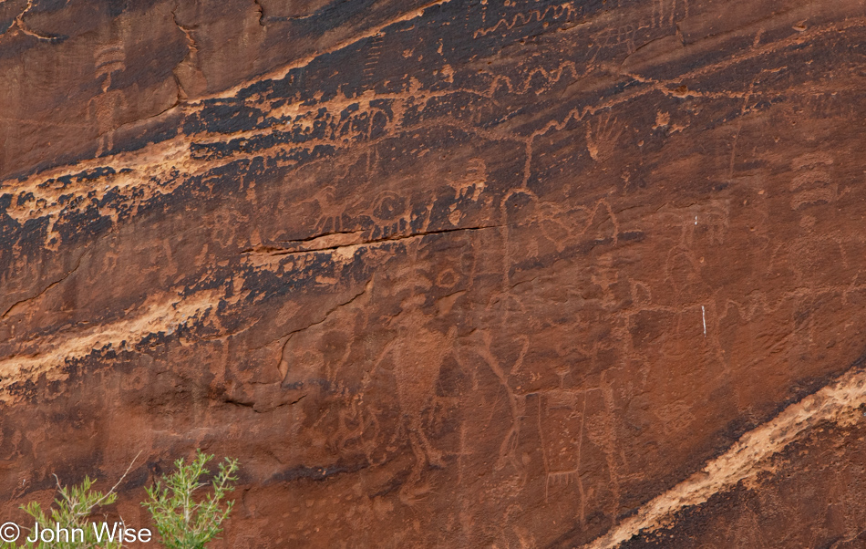
From one, the many arise. Somewhere in the distant, unknowable past, someone realized they could peck an image into the desert varnish found on rocks. This one person left a mark, followed by many others imitating what had been done by this pioneer. We can never know the first stone artist here in the Desert Southwest, but we can relish that hundreds if not thousands, followed the lead and offered the future a mystery. From an anonymous author, possibly during the 16th century, someone penned a nursery rhyme titled “Hey Diddle Diddle” that spoke of a cow jumping over the moon. This panel has me thinking of an antelope in the form of a constellation that jumps over the terrestrial relative. Now I’ll have to reconsider the petroglyphs I’ve seen and wonder if I’m not looking at nursery rhymes.

Without change, something sleeps inside us and seldom awakens. The sleeper must awaken.” ― Frank Herbert, Dune.

Gates also act as blinders, stopping us from seeing the full picture, while a veneer of dust can obscure what we think we are seeing. Where we humans are in our perception of the world and our place within the universe is still hidden behind many a door, gate, much haze, and darkness. In dream worlds, we manifest glimpses of potential we might be afraid to experience for ourselves; we find shelter in the safety of our heads, knowing dreams are not real. When we open our eyes and stare into the light of knowledge, we risk blinding ourselves with truths that make us largely incompatible with many of our species. There is an inherent cost that arrives with even a glimmer of enlightenment, and that is you will be simultaneously alone and forever locked solidly in the multitude of the whole of everything.

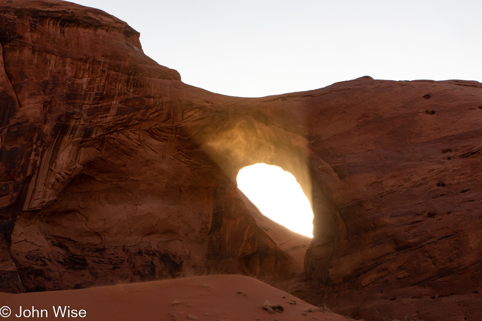
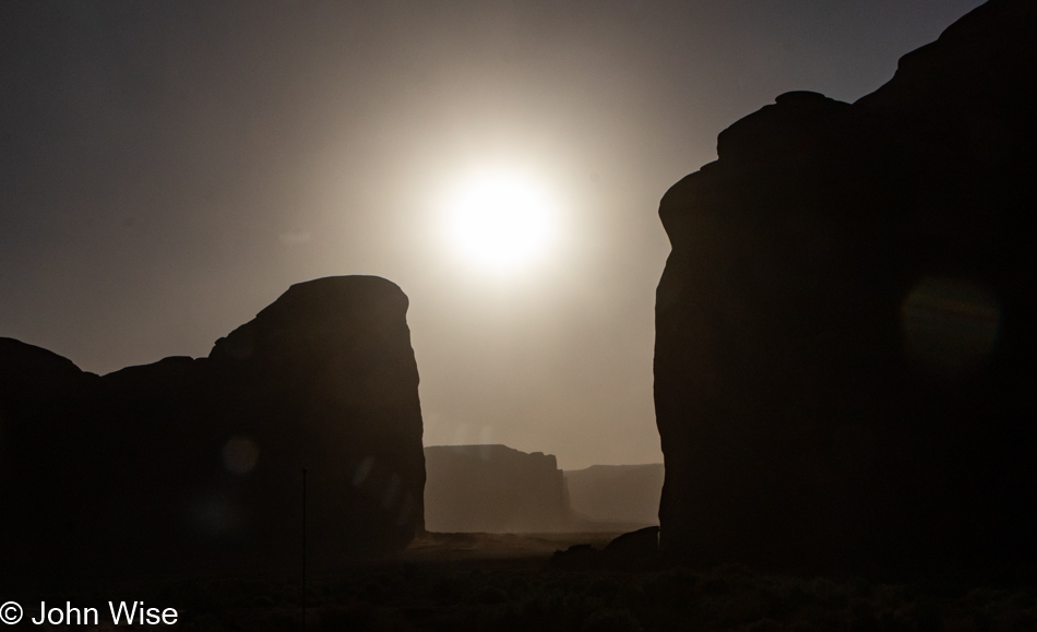
As above, so behind. Oh, I know this is a modified version of the better-known quote, but this is an intentional re-imagining due to the circumstances I find myself in. I don’t know the proper name for this version of crepuscular rays, a.k.a. god rays that have taken shape due to the dust blowing through the Eye of the Wind, but the idea of light beaming out of the eye instead of only inward could also be referred to as another moment in awe. As for the play on the quote, I began this paragraph with, look behind me.

The sun passes through the Eye of the Wind while the space between is being observed by countless brain cells in our individual heads, all firing to interpret the moment. On one hand, eyes and minds are not precise recording devices, but they do act extremely well as pattern recognition machines. While we cannot pull these images from our memories with the same fidelity as a photograph, when we do see something similar, we are able to compare it to the impression left behind and find familiarity to better understand the impression. We do not only see with our eyes but also with our memories. Which then begs the question, what memories have you tried to collect?

In Henry Wadsworth Longfellow’s poem titled, A Psalm of Life, the following stanza resonates with me.

Lives of great men all remind us
We can make our lives sublime,
And, departing, leave behind us
Footprints on the sands of time

The sand of time is an old idiom referring to grains passing through the constriction of the hourglass that should have us thinking about how our moments are passing through the constriction of our limited existence. If you do not try to capture those grains and simply let them float away, you will not have been available to witness what time could have offered you.

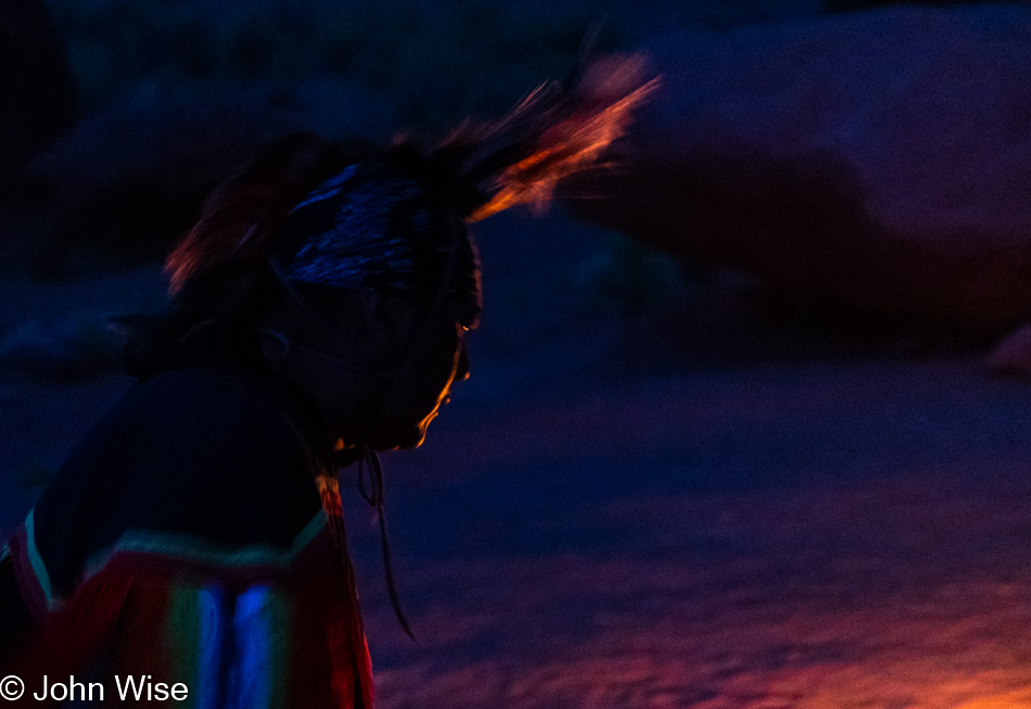
The sun has set; its rays cast light elsewhere. The blowing sand is beginning to settle in the late day as a number of us gather around a table to share a meal. The others arrive under their own circumstances with ideas that direct their narrative, but no matter the background, we are here with those who feed us, sing to us, and tell us their story. Around a fire, we are reminded that the light shining on our faces is temporary, but for a moment when we were on hand trying to understand the impossible and magnificent.

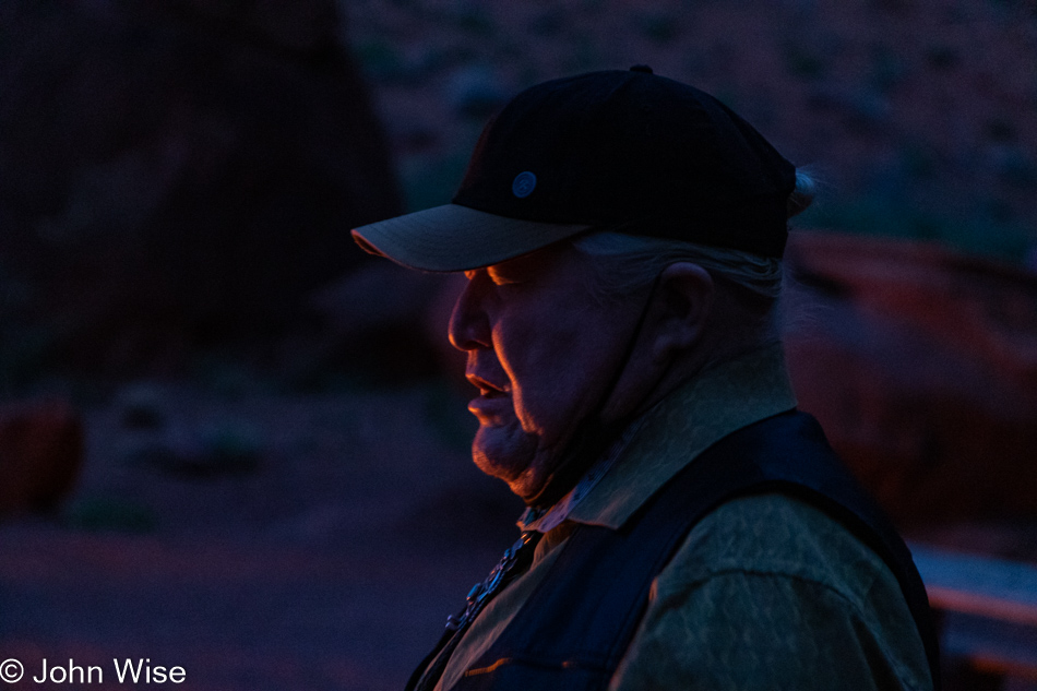
How many of us never learned to look into the flickering light of memories that might allow us to see not only our ancestors but some part of life as big as love? Can you beat a drum, sing a song, or tell of the extraordinary if the images within are a frenzied blur of chasing aspirations and goals that have nothing to do with one’s soul, whatever that might be?

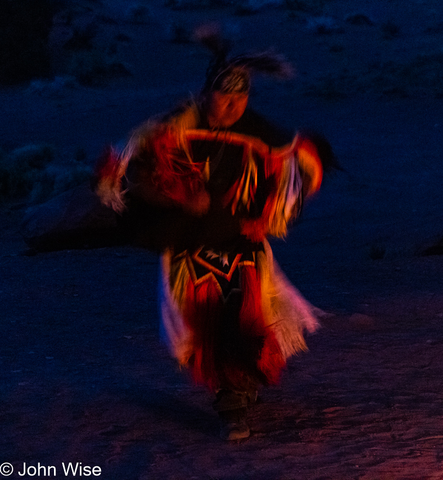
Dance with beauty into the heart of the night. Paint your dreams so they intertwine you with amazement and wonder on your path to see the light of love and life. When you wake, be sure to throw open the door welcoming the sun into your new day, turn around, and shine your own light into the universe. You are now dancing.

Mexican Hat and Surroundings

Mexican Hat, Utah

Today started out on the wrong foot, with us deciding at 5:00 am that the commitment to haul ourselves nearly 4 hours north wasn’t going to be happening. The original idea had us revisiting Horseshoe Canyon, but after a night of sleep that was more akin to playing the rotisserie chicken game until 5:00, when I finally dragged my exhausted body over to turn on the loudest air conditioner in all of southern Utah (that at least helped get some sleep), we decided to change plans.

It was already after 7:00 when we finally hit the road, a bit disappointed that we bailed on our plans at the last minute, leaving us relatively aimless other than knowing we were going north. We drove into the gloomy, overcast morning. The only thing we could muster those first minutes was stopping at the Mexican Hat rock on the other side of town.

Mexican Hat, Utah

Not more than a few more miles beyond that was the turnoff to head out of Goosenecks State Park. This, too, would be a revisit, but sometimes it feels that almost everything in America qualifies as that for us.

Goosenecks State Park in Mexican Hat, Utah

Back a hundred or so years ago, on our last trip out here, we believed we were the only people at this overlook; that’s not true this time. Maybe it’s a Memorial Day Weekend thing, but a half dozen campers are parked along the rim, and there are a few other visitors out here just for the peek into the depths below.

Goosenecks State Park in Mexican Hat, Utah

It’s a beautiful 2-mile roundtrip walk out to the trail’s end. Along the way, I’m enchanted by the rock formations we’re walking over as there are hints of a marine past where it appears to Caroline and me that a shallow sea influenced the look of this fossilized sandstone. Caroline picks up on the thought that these look as though they have a milky translucency where she can glean hints of the underlying structure that formed these rocks.

Goosenecks State Park in Mexican Hat, Utah

I’ve stared hard, contemplated, and searched my memories, trying to find what this reminds me of, and maybe the best I can come up with is a dry lake bed that’s been compressed by subsequent layers accumulating on top of it. How often do we stop to consider just what it is we are walking on? The reality is that we are walking atop history, usually oblivious of how familiar we’d be with it. If I knew I was walking on a lake bed, a shallow sea, or a broad river bed, it would change how my imagination would contextualize the environment I’m experiencing as I strain to see what might have been prior to my arrival.

Heading up the Mokee Dugway in Mexican Hat, Utah

With the overcast sky, we agree that there’s nothing to be gained driving up the scary Mokee Dugway and that we will take the right turn just before the ascent and drive through Valley of the Gods before returning to the road that will take us up Bluff way.

We made the right turn, and not 5 seconds later were making a U-turn to face our fears and drive up the dugway; not my idea, mind you. We know we’ve driven down it a couple of times, but we had no recollection of going the opposite direction, not to say we haven’t, as in having taken so many road trips across the Southwest, maybe a thing or two gets lost to time.

Heading up the Mokee Dugway in Mexican Hat, Utah

It’s a white knuckle climb up the 3-mile (4.8km) series of switchbacks that will take us up the 1,100 feet (335 meters) needed to find our way onto the top of the mesa. We had the opportunity to learn one bad aspect of going up instead of down: if you encounter someone going down on the really narrow parts, they have the right of way, and you have to back up. This was the point where Caroline was questioning her enthusiasm for this diversion instead of an easy drive through the Valley of the Gods.

Heading up the Mokee Dugway in Mexican Hat, Utah

By the way, when we got home after this trip, we looked at our old photos that lay witness to our travels over the Mokee Dugway and now have to question if we’ve ever driven down the narrow dirt road. How could we have lost those memories that we’ve apparently always driven up the Dugway?

Butler Wash Anasazi Ruins Trail in Bears Ears National Monument, Utah

Not prepared to turn around and return the way we came, we continued up the road into Bears Ears National Monument. We passed one spot that talked to our curiosity, but it was supposed to be part of tomorrow’s adventure and so we just kept on driving. When we saw the Butler Wash Anasazi Ruins Interpretive Trail sign, we turned in there as it sounded compelling.

Butler Wash Anasazi Ruins Trail in Bears Ears National Monument, Utah

Before our next mini-adventure in the continuing bigger adventure, it was time for lunch. We turned to a new favorite, bologna, and boiled egg sandwiches, but it turned out to only be a snack as in a couple of hours, we’d pull over for another round. Done with that, it was time to hit the trail.

Butler Wash Anasazi Ruins Trail in Bears Ears National Monument, Utah

Back when accretion was at work accumulating successive layers of sediments, something was happening here that will remain inexplicable to me. While I have some sense that the oxidation of iron is playing a role in creating rust, I’m desperate to know precisely why this bit of sandstone is red and orange. If it’s being excreted over time as it’s exposed to the elements, then why just here? What are the processes going on in the sandstone that are drawing particular minerals to this location? I should have been a geologist.

Butler Wash Anasazi Ruins Trail in Bears Ears National Monument, Utah

There’s something missing from this photo. Namely, the layers of earth that used to be here but are now scraped from view by good ol’ Mother Nature, who eroded that history and delivered it somewhere else. What remains allows us to see the sand dunes that were petrified somewhere in the distant past. Like a kind of two-legged ant, we walk in the gap of time where once a hidden sandwich from another era hid the story of the earth unfolding.

Butler Wash Anasazi Ruins Trail in Bears Ears National Monument, Utah

The easy hike was a beautiful one that brought us to an overlook of the ruins; sadly, it was marred by “that” family who are in the universe all by themselves. Loud, obnoxious, and oblivious to anyone else who might not want to be witness to their antics on the other side of a barrier or running over a path as they tried to find a way to visit the ruins in the caves that seem off-limits to us.

Bologna and egg sandwich

Back at the main north-south highway, we took a short drive north to Blanding because, though it was mid-day, we’d not yet had coffee, and we were in dire need. With headaches fading (yes, we are addicted to caffeine) and pep returning to our senses, it was a snack or eat; we pulled over for round two of our culinary delight. Looks appetizing, huh?

White Mesa, Utah

I don’t believe White Mesa, Utah, ever had a golden age, but then again, which Indian lands ever had that after colonization?

Bluff Fort in Bluff, Utah

How have we failed to visit the Bluff Fort on previous visits to this corner of Utah? Cynicism is the likely answer, as there’s a certain amount of cheese factor going on, but today, this was a GREAT stop. Thanks to the docents and staff for sharing some great details that told the harrowing story of the pioneers who first came into the area via covered wagons that should have never made the trek.

Bluff Fort in Bluff, Utah

Well then, things come into focus after returning to Phoenix and searching like mad for almost 5 minutes for clues as to why we never stopped at Bluff Fort. The visitor center/co-op building, which is the main focal point of a stop here, wasn’t opened until 2013, and somehow, a decade passed by without our passing through Bluff.

Bluff Fort in Bluff, Utah

Learning of the hearty natures of the pioneers who toiled to reach this remote outpost is nearly gut-wrenching. They sliced their way through a small gap in a wall of rock so they could go forward, but not before having to use men, horses, and ropes to guide their wagons down the steep, rough trail they’d forged. Then, there were floods from the nearby San Juan River and the simple hardships brought on by being so far away from any other community.

Today, Bluff is heading for the toilet. My apologies to the citizens of Bluff, but the Bluff Dwelling Resort & Spa is the ugliest nod to the artificial opulence desired by a certain elitist segment of our population who have no compunction with gentrifying authenticity with their fake realities. Don’t get me wrong, I really do dislike the pretentious banality that often arrives with wealth, but what is an otherwise poor community supposed to do when the majority of Americans can no longer afford to get off the beaten path? Again, let’s try to find some honesty: that majority could afford to come out to these out-of-the-way destinations, but why would they want to walk away from their self-imprisoned existence sitting in front of another iteration of their favorite videogame, the 17th season of some lame series, or from witnessing the 48th time their favorite sports franchise meets some other team.

Just like Jackson, Wyoming, Steamboat Springs, Colorado, and Sun Valley, Idaho, those places won’t fade off the map like so many American cities as the wealthy have realized the incredible value of living somewhere profoundly beautiful. I guess Bluff, Utah, has the added benefit of having the San Juan River running through it, which in the southwest United States is a treasure when such a valuable resource such as water is disappearing in the larger communities being left by the rich who can gentrify the places they want for themselves. No, seriously, I’m not bitter or anything.

San Juan River at Sand Island in Bluff, Utah

Inspired at the moment by a sign reading Sand Island that pointed the way down to the San Juan River, a quick left turn not only brought us riverside but there’s an incredible panel of petroglyphs.

Petroglyphs near the San Juan River at Sand Island in Bluff, Utah

I’ve interpreted this panel for the first time ever; it reads: don’t allow the wealthy interlopers to steal the lands and resources available to all. Too late ancient ones, our souls were cheap fodder easily traded with the hopes we’d be able to take a selfie of ourselves with some rich and famous douchebag who was second in importance only to our children. We are a collective of toolbags. About now, you must be wondering, “Jeez, John, what crawled into your crack?” The sad reality of dreamless people who want nothing more than cheap gas, bullets, and drive-thru convenience.

Petroglyphs near the San Juan River at Sand Island in Bluff, Utah

There are three figures here with three bars over their heads; they are tapping into other dimensions to discover how to cope with the future that is going to arrive, where much of their world would disappear in the clutch of the conquering force. Today, I’m one of those persons with three bars over my head looking into the higher dimension, trying to discover how to cope with the conquering force of wealth that has no space for the peasantry of common people just as our ancestors had no space for the indigenous people that populated these lands before them. All around me, I witness the mass of America moving onto a virtual reservation where the resources of the intellect have been stripped bare.

Highway 191 south of Bluff, Utah

If only I could find the time to write these narratives in situ when I’m resonating with the beauty and happiness of the moment instead of trying to capture recollections of these days a week later. In the interim, there have been 17 mass shootings, with the most recent one happening in the past 12 hours right in Phoenix, Arizona, where I’m trying to write this. To say I’m distracted by our abhorrent and vulgar attitudes when these incredible sights should soothe our abysmal and wretched selves would be an understatement. Aside from Caroline’s and my opportunity to indulge in such wonderful distractions, where am I supposed to find hope that America isn’t headed into the abyss of self-destruction?

Valley of the Gods in Mexican Hat, Utah

But this post is not supposed to be about the woes afflicting those I cannot see; I’m here to capture not only the visual impressions of a couple in love traveling into deeper love but also to write about the gravel, clouds, scrub brush, dust, bumps, colors, and the oohs and aahs found between the sighs of wow from the woman traveling with me.

Valley of the Gods in Mexican Hat, Utah

Welcome to Valley of the Gods.

Valley of the Gods in Mexican Hat, Utah

Here, in the presence of such a large nature, we bow in the silence of awe. It was either something like that or a non-stop series of under-the-breath utterances of wow in between, repeating how incredibly lucky we are to afford ourselves these experiences.

Valley of the Gods in Mexican Hat, Utah

Had we opted to venture onto this 17-mile drive this morning, we would have traveled under the gray, overcast sky, so this is working out perfectly. Another thing, compare the price of this drive (FREE) with that “other” 17-mile drive ($11.25) taking looky-loos past pricey homes (median price about $5 million depending on the source) and derpy golfers who effectively dropped a testicle on the green as an offering to play Pebble Beach ($575 for a round) and you’ll either guess that we are relatively poor or class snobs resentful about our own bourgeoisie status, maybe both?

Valley of the Gods in Mexican Hat, Utah

I admit that the 17-mile drive in Carmel, California, has the Pacific Ocean, but with a little imagination, one can still witness the inland sea, oceans, and lakes that once welcomed marine life right here, and don’t forget the dinosaurs.

Valley of the Gods in Mexican Hat, Utah

I just went on an internet hunt to find out if this butte had a name, and while I came up empty-handed, I did find more than a few unsatisfied visitors to Valley of the Gods. I could take 100s of images of a pile of poop on a sidewalk, but I doubt I would ever find even one that represented an aesthetic that might inspire others to look for the best in random poop left in our environment. On the other hand, there are those who share with others reviews such as, “Meh” and “The first few miles were OK. After that it got pretty boring” about a majestic place such as this. I understand that we all have a different sense of what constitutes beauty, but to be so devoid of empathy, soul, intrinsic values, or a basic understanding of how time and earth sciences create such unique complexity just casts those imbeciles into the pool of troglodytes.

Valley of the Gods in Mexican Hat, Utah

Oh my god…just look at all that dust blowing up in the hostile winds, trying to antagonize my allergies and ruin how clean my car is. What’s wrong with nature obscuring my view and wrecking photos? I hate Valley of the Gods; it’s just a bunch of boring meh-ness with no redeeming qualities aside from the fact it doesn’t carry an AR-15 to mow us down as we drive through. Why are we even out here in this monotonous land of endless tedium where everything is ugly and stupid? You know what’s tedious? This snark that detracts from settling into extolling virtues of yet another place we passed through in, yep, you can guess it, AWE!

Valley of the Gods in Mexican Hat, Utah

Greenery in the desert is a sign that water runs through here. The astute will know that this is a wash on those rare occasions when rain has been falling in the surrounding area. I’m simultaneously happy we are not here while it’s raining (we’d certainly be stuck in the mud) and disappointed that we can’t be on hand for one of those moments when water feeds the dry earth we’re traveling over right now.

Valley of the Gods in Mexican Hat, Utah

Every turn, every moment, every view is changing the way things look. By the time we reach a place, it often appears quite different than it did from a great distance, from just 200 feet away, and the spot we stopped at to take a photo. Perspective shifts sure are easy in the great outdoors if you are looking for them, so why are they so hard to come by as people look within?

Valley of the Gods in Mexican Hat, Utah

The sun will set on the landscape but only temporarily, as opposed to the imminent day when it sets on us for eternity. Until that day, how many sunrises and sunsets will you have seen, not metaphorically in the sense that you were aware they were happening and could picture them in your mind’s eye but that you’d seen with your own eyes? Why isn’t the real mark of luxury the cumulative number of times we can lay claim to having watched waves lap at the shore, witnessed the leaves of fall change color, seen the bud of a cactus blooming, or the coming into focus of a rainbow spreading across the sky? The obvious answer is that we cannot easily parade impressions around but we can arrive in the right car, have the big home, or the pricey clothes that offer nothing about how rich someone is experientially.

Mexican Hat, Utah

Maybe you’ve read all this before right here on my blog, but I’d argue that just as I never tire of seeing this rock balanced atop a small butte that inspired the name of this community of Mexican Hat, it, like my words, enter reality and hang out until time and nature erodes them until they crumble and are lost in time. So if you continue returning to these pages, the canyon that is John is what you are visiting, and while the angle of the sun, the position of the clouds, and the time of day might alter how things are seen, you might witness much the same thing until an arm from my river of thought carves a new pathway that breaks out of the routine flow.

Mexican Hat, Utah

Enough of this; it’s time to eat, not only for the day the events pictured above took place but at this moment I’m writing these words. Seeya later, sun. With my senses satiated, I need to heed the beckoning of my stomach, though compared to the exquisite nature of the meal that followed on this travel day, the lunch I’m about to jump into pales in comparison. On second thought, there is no comparison.

Hank Whipple at Mexican Hat Lodge - Home of the Swingin' Steak in Mexican Hat, Utah

This is grill master Hank Whipple, whose family operates this outpost called Mexican Hat Lodge, affectionately known as the “Home of the Swingin’ Steak.” Last night, this man grilled me up a 20-ounce (almost 600 grams) ribeye steak (entrecôte), but eating that whole thing after 7:00 pm was a mistake in judgment because that hunk of meat lying in my gut commanded serious attention, thus disrupting any hope of blissful sleep. So, tonight, not only are we eating earlier, but I’ve opted for the more manageable 8 ounces (228 grams) of flank steak. As for Caroline, come on, she’s always reasonable.

Meandering Hopi and Navajo Lands

Wigwam Motel in Holbrook, Arizona

Only a few hundred feet from the railroad tracks and well within earshot of the rail crossing just up the road, our sleep was punctuated by the sound of trains passing throughout the night. Small price to pay considering we’re sleeping in a 72-year-old concrete wigwam. And not just any wigwam, mind you; John Lassiter of Pixar passed through this area on vacation some years ago and, inspired by many of the sights he had encountered (including the Wigwam Motel), he would make some of those locations famous as they found their way into the animated feature film Cars.

Wigwam Motel in Holbrook, Arizona

During many of our previous visits to Holbrook, we used the old town here on Route 66 as a waypoint before moving on to other places that drew out more of our curiosity. Well, today, we’re taking the time to walk around in order to get a better feel for the place.

Holbrook, Arizona

Last night, I forgot to point out the difference in gasoline prices between the Phoenix area and these northern climes: we paid $4.39 a gallon up this way and $5.19 down in Phoenix. Why this large delta in prices? This doesn’t make sense as hauling fuel further away should also impact prices, but I think what’s at work is that the oil companies know that the populations of big cities have more income, and so, in effect, they can squeeze us for greater profit while only making a reasonable amount of money in rural areas that would otherwise harm the lower-income population. That, or we are subsidizing rural America so they can better survive what is often a meager poverty-level existence?

Holbrook, Arizona

Walking down Hopi Drive, once the old Route 66, offers a tragic view into the nostalgia that hangs over this part of Holbrook as while a few businesses are hanging on most are gone, and what remains grows long in the tooth. Surprisingly, an old movie theater is still here, and had we known, we likely would have stopped in last night for the only showing of the day at 7:00 pm of Top Gun Maverick. Joe and Aggies Cafe, we’ve eaten at before, is shuttered, and its dusty windows offer a glimpse into a time capsule.

Holbrook, Arizona

While we’ve always had a soft spot for old signage, it’s only now occurring to me that signs such as this one at Butterfields Steak House would never be affordable today. Handcrafted, heavy steal, blinking lights, and neon towering 30 feet over the road, these are now relics of the past for old towns like this. I’ve likely shared this before, but it was back in 1969 or so when I first passed through this area and had the sound of the passing trains during the night seared into my memories. While I can never know which motels or restaurants we stopped at during our epic cross-country trip from Buffalo, New York, to Long Beach, California, where my father was living, I do have distant images stored in my memories of waiting for tables at noisy cafes, looking at wildly colored desert landscapes, and endless roads.

Holbrook, Arizona

Some of the old motels have been converted into long-term rentals, albeit without any of the services that once serviced rooms every morning, invited guests into pools, and brought people into experiences that would last lifetimes.

Holbrook, Arizona

Decaying places become sad tragedies of forgotten pasts when a new generation has little to no connection to what has been. At least with the ancestral Native Americans, there’s mystery remaining in the scattered ruins, eliciting a deeper wonderment where we try to imagine something so distant that it defies our ideas of just how things worked.

Holbrook, Arizona

When it comes to America’s relatively recent past, I think most romantic notions are gone, and the antiquated, weathered relics are skipped over as our modern car culture seeks out drive-thru convenience and luxury that allows people to separate themselves by class compared to 60 years ago when we were all just Americans out for adventure into the unknown.

Holbrook, Arizona

Achtung Europäer, this is part of why you want to travel to the United States. It doesn’t matter if Romo’s on Route 66 is good or bad, but you will have eaten Mexican food at a diner with a mural of a taco, burrito, and a chili pepper racing down the road through Monument Valley and past petrified wood as you yourself move between those areas.

Holbrook, Arizona

How does one shit on the past? Read the bottom of the sign, Vape Smoke Shop featuring vapes, E-juice, and CBD. Sure, life evolves and goes on, and who buys rocks these days anyway or wants to stop in at a trading post to buy tchotchkes from an old man selling junk made in China? All the same, we don’t turn old churches into sex shops (not that anyone goes to those anymore either), but to desecrate through neglect and abandonment the adornments that were part of a prosperous past is the ignorance of a culture that has failed to understand exactly what it is that makes other places that cherish their history so attractive.

Homolovi State Park in Winslow, Arizona

Homolovi is Hopi for “Place of the Little Hills,” and that’s exactly where we headed after leaving Holbrook.

Donkeys at Homolovi State Park in Winslow, Arizona

Within eye-shot of Interstate 40 is this state park that not only features donkeys staring at people menacingly but there are also seven ancient Pueblo sites dating from 1260 to 1400.

Homolovi State Park in Winslow, Arizona

The people who lived here are called the Hisat’sinom, which is Hopi for “long-ago people.”

Homolovi State Park in Winslow, Arizona

While outsiders might consider this a site of Native American ruins, the Hopi consider it to still be spiritually alive. As such, the broken pottery shards scattered across the Pueblos were the belongings of ancestors; they are not here as souvenirs, and out of respect, visitors should do their best not to collect the personal belongings of others. Just try to imagine that your grandparents died and your family was preserving their home as a shrine to their lives, but random visitors wandered into their bedroom and helped themselves to your family’s heirlooms.

Homolovi State Park in Winslow, Arizona

I wonder how many times I’ve written the explanation that this underground room is a kiva used for ceremony and political purposes?

Homolovi State Park in Winslow, Arizona

Maybe it looks desolate to us here 600 years after the villages were abandoned, but we can’t know life here back when the nearby Little Colorado River sustained life. As white Americans moved in back in the 1870s, they made off with many of the stones from the pueblos to build their own homes in a place such as Sunset, Arizona, that was eventually washed away during one particular bad flood of the river. There were other towns out here that didn’t make it either, such as Brigham City and Obed, while Joseph City, with a small population of 1,307 inhabitants, has managed to hold on.

Homolovi State Park in Winslow, Arizona

As of today, 2022 will be known as the Year of the Lichen in John and Caroline’s fake Chinese calendar of themed years.

Donkeys at Homolovi State Park in Winslow, Arizona

A gang of thug donkeys challenges us to just try passing them without making offerings. Tired of dried grass and some noxious plants that are unpalatable to all life, they held their ground with a menacing look of “Give us carrots or suffer the consequences.” Sorry, donkeys, but we have popcorn, bologna, boiled eggs, granola, and soy milk in the car, not exactly gourmet donkey fare.

Homolovi State Park in Winslow, Arizona

Loud squawking coming from a crevice allowed us to spot a raven’s nest with two juveniles awaiting feeding from mom and dad. But it was the thing that was nearly overlooked that should have first grabbed our attention…

Homolovi State Park in Winslow, Arizona

…the ancient nest remains of what I can only guess is from eagles that once lived in the area. When I asked at the visitor center what this was, I was told that it was the accumulation of debris from the ledge above. Right, a small bit of lifeless rock above somehow collected twigs of a near-uniform size and then deposited them right here at the base of this cliff-face. I’d guess that eagles have been nesting here for centuries and that even before this easily identifiable pile was built, there’s an even older layer that sits below the small number of rocks that fell at some point in the past. Those pieces of sandstone should be able to be aged depending on the amount of patina if any, that exists on them. Golden eagles still live in the area and are of religious significance to the Hopi people. Come to think about it, maybe the person at the visitors center didn’t want to identify exactly what this was in order to stop the curios from dissecting/desecrating this beautiful old nest.

Homolovi State Park in Winslow, Arizona

Eagle food remains.

Homolovi State Park in Winslow, Arizona

Most of the stones that comprised this village closest to the river are long gone as I guess they were the easiest to pilfer for the town down the road that is no longer down said road that is also no longer in existence.

Arizona Highway 87 in Northern Arizona

Well, we know where we’re goin’
But we don’t know where we’ve been
And we know what we’re knowin’
But we can’t say what we’ve seen

And we’re not little children
And we know what we want
And the future is certain
Give us time to work it out

We’re on a road to nowhere
Come on inside
Takin’ that ride to nowhere
We’ll take that ride

Arizona Highway 87 in Northern Arizona

Junior Geologist John is going out on a rim here by taking a WAG (wild-ass guess) about what we are looking at. Could this be a cinder cone that sprouted out of some sandstone hills that eroded all around us? Could these be here because the lava covering protected them from being scraped off the landscape?

Arizona Highway 87 in Northern Arizona

There we were; one minute, we were admiring some horses walking a fence line, and the next…

Somewhere between Indian Route 4 and Route 41 on Hopi Lands in Arizona

…we are driving down a dirt road that disappears on the horizon.

Somewhere between Indian Route 4 and Route 41 on Hopi Lands in Arizona

After following the dirt road for an infinity, we found ourselves beginning to wonder, just how long is infinity?

Somewhere between Indian Route 4 and Route 41 on Hopi Lands in Arizona

Hello, startled young bull; we apologize for interrupting your meal, but do you know where we are? He answers, “Down the road is a freckled horse, but he’s a bit aloof and unlikely to help you, though he certainly knows these lands.” Well, thanks, but I now have to wonder how is it we were able to communicate with a bovine?

Somewhere between Indian Route 4 and Route 41 on Hopi Lands in Arizona

Hey, Mr. Horse with the freckled neck, the startled bull behind you told us you know the way, “I do; just follow me.”

Somewhere between Indian Route 4 and Route 41 on Hopi Lands in Arizona

Well, this just looks like more of the same, only different.

View from Black Mesa, Arizona

After countless miles in the dirt, sand, rock, uphill, and over dale, we immediately recognized the land far away from this overlook. Our road would take us right through the gap in the distance to Tsegi, Arizona.

Burned remains of the Anasazi Inn at Tsegi Canyon near Kayenta, Arizona

The Anasazi Inn that once stood here on Highway 160 is now mostly gone. Fire, looting, and possibly other forces have decimated this plot of land until what remains standing is a shell seen here and a couple of other remnants. The image in this photo is from a collaboration between poet Esther Belin and the photographer of Jetsonorama. On the left of the mural was the following note:

BELIEVE – Afterward we will get up. All together, with the sound of canyon wind howling, red clay masks preserving our faces. Our government clothes tattered, no longer creased with false doctrine. The pressurized steamed language escapes from the pores of our skin. The monogrammed label “Property of U.S. Government” erased from memory. Our teeth, sweat, saliva, fingernails, strands of hair recompose as the daughter of First Man and First Woman. The four support pillars reconfigure the directional mountains. The zenith and nadir bolt lightning into our backbone. The stone knife in our hand slays monsters. The sun rays fasten us snuggly to Nahasdzáán. The rainbow tethers a shield over us. All together, the intertwined winds breathe again. — Esther Belin

My apologies for not being able to maintain the format of the poem. Should you want to learn more about the project it might be found between www.jetsonorama.net, www.justseeds.org, and www.artjounalopen.org.

Burned remains of the Anasazi Inn at Tsegi Canyon near Kayenta, Arizona

Someone out there used to stay at the Anasazi Inn in Tsegi, Arizona. They don’t know yet that it’s been wiped off the map, and maybe that person has some random memories of having stayed there. Might they remember the linoleum floor that was part of the experience? This is nearly all that is left that is still recognizable; in time, it too will be gone, and only the impressions still surviving in brains will be left.

Agathla Peak in Navajo or Spanish: El Capitan south of Monument Valley in Kayenta, Arizona

There should be many things between here and there or here and where we’ve been but often the dearth of things capturable is bigger than the space they fail to fill. Opportunities to cater to desires and experiences unknown to those moving through an environment are lost when the means or knowledge remain in a void as inaccessible as my wishes to discover what I’m missing. Not being Diné nor having the means of meaningful investment, I cannot act as the proxy that would bring forth what lies in the margins of my imagination that would take us beyond the space between.

Agathla Peak in Navajo or Spanish: El Capitan south of Monument Valley in Kayenta, Arizona

At least there’s El Capitan waiting to serve our senses.

U.S. Highway 163 looking towards Monument Valley

And after that, our first glimpse of Monument Valley.

Monument Valley from Forrest Gump Point in Mexican Hat, Utah

Little did I know what I wasn’t seeing here at Forrest Gump Point; I wasn’t seeing the crowds that apparently wait for the weekend before making their pilgrimage.

San Juan River in Mexican Hat, Utah

Passing over the San Juan River is the turning point, and I know we are not far from finding our pangs of hunger satiated by a slab of cow that has been foisted upon a swinging grill where it will cook to perfection over an open fire. Then, in the shadow of Valley of the Gods, we’ll sit roadside as we have many a time prior and enjoy another aspect of perfection as the sun sets and we bask in full stomachs and the knowledge we’ve already arrived and have no further to go than upstairs to survive the Mal de Puerco.

Short Hike in Bryce and Go Home

Yesterday’s pain party was worse than I whined about in yesterday’s blog post, so on our way back to our hotel after dinner, we’d decided we’d had enough and that Sunday would be a chill day with some sightseeing, but we’d lay off the hiking. After waking and packing the car, we turned left out of the driveway in the direction of home. We didn’t make it a mile before I suggested that we should at least take a look at the Tropic Trailhead that was just around the corner. Caroline agreed, and we whipped a U-turn. Both of us felt pretty good, and we agreed that at the first sign of knee or hip pain returning, we’d turn around from this trail that was rated as easy.

The elevation change is so subtle that it’s almost like walking on level ground out here; we sigh a relief and confirm that we are both okay and ready to continue. That solo deer walked along on our right for nearly a minute before jumping forward and then cutting right to cross the trail; once more, I’m foiled from getting a better photo as I failed to anticipate needing a zoom lens. Maybe if I write this enough times to myself here, I’ll remember to bring it next time. I’ll also point out that nearly every trailhead has a sign warning people parking there to NOT leave valuables in their car, and there are times we simply don’t want to lug that 3-pound lens in Caroline’s backpack. Oops, I think I wrote “we” in that last sentence when I meant Caroline. I might even feel guilty if I saddled that weight on her shoulders with the water, sweaters, food, sunblock, and the multitude of other things she takes responsibility for carrying as I’m too sensitive to be bothered with anything that detracts from taking perfect photos. Just try to think of it as I’m the deer moving lithely, independently, and free of burden in case I have to respond to capturing something important while my devoted wife remains at a safe distance, ready to support me and react to my beck and call. We call it happiness through structure. She’ll call this last bit BS after reading it, I’ll bet ya. [Eye rolling intensifies – Caroline]

Shenanigans and nonsense are not what we are here for, nor what my writing about the day’s events should be about, but after this weekend’s slog of writing a mega-ton of love stuff, I’m nearly exhausted at even the idea of trying to share meaningful prose here. So, on that note, these are beautiful orange and white rocks that also fall in the category of hoodoos, which have everything to do with our hike into Bryce Canyon from the only way in that doesn’t descend from the rim.

It’s only a 1.8-mile hike to the fork in the trail, and as long as we don’t hit any steep parts along the way, we feel confident we’ll have a good majority of the requisites steps we need for the day or about 8,000 of the 10k we aim for. Considering that we were comfortable with just heading south out of Utah for the trek home, we are thrilled that we didn’t cut bait and go.

Met a Swiss couple crossing our trail as we reached the spot where the Peek-a-boo, Queens, Navajo, and horse trails converge. They went left, and so we went right to not be right on their heels.

Hey, wait, I thought we’d agreed that there would be no up or downhill of any significance. With neither of us finding insurmountable pain in our joints, we decided that it was okay, but just this one to see what’s around the bend. There wasn’t a spectacular view, so after about five more minutes up this horse trail, we were about ready to turn around.

This was as far as I wanted to go while Caroline continued up to the saddle between these hoodoos as her gut said unto her, “A great view is just ahead.” Wrong. Turn your ass around and return from whence you came.

Somewhere down on the forest floor below is where we are heading.

Did I not see this on the way up the trail, or does it just look that different from a change in perspective?

We are on the other side of the branch in the trail heading up Peek-a-boo.

The idea is to go as far as we’re still comfortable after starting on the trail in a counter-clockwise direction.

The Peek-a-boo is only 3 miles long, and we half-considered trying it, seeing our entry into the basin had already afforded us the chance to avoid the seriously difficult part of the trail that descended from Bryce Point and required us to leave that way too had we not hiked in on the Tropic Trail. But here in the curve the trail narrowed while the hillside dropped precipitously, so that’s it, I’m done, no more exposure for me.

Having considered no hiking at all today and now being on the verge of 5 miles, we are happy that we’ve seen as much as we have.

Seeya some other day, Bryce, or at least we can hope to return someday.

We are back in Arizona, where the winds have gathered steam and a considerable amount of dust. Our time out here on the Colorado Plateau is growing short, but our desire to return home before dark is curtailing the throwing that concern out the window so I can photograph every sight that knocks at my sense of sharing what I find intriguing or attractive.

As much as we are moving forward, albeit relatively slowly, others are simply in a hurry. They race up behind us, except I’m now old enough that when I see them a mile behind me, I start looking for pullouts so I can take a short pause, allowing the insane to speed into impatience. This view from a pullout is just one of those moments.

The scale here is lost in the midday sun, where shadows are rare. The amount of dust held aloft by the strong winds also fails to look as foreboding as it did to our naked eyes, but no matter as we’ll hopefully retain a sense of things long after we forget that we were traveling through the Vermillion Cliffs at this point after leaving the North Rim of the Grand Canyon behind us.

Come October, we’ll be right back here in the Marble Canyon area as we take a night before climbing up the road to spend the night at the Grand Canyon, north rim, of course, on the last day of their season. Come to think about it, we will drive through here again at the end of June with a night in Fredonia, Arizona, on our way into the Wasatch Mountains east of Salt Lake City, Utah.

Our worst fears about driving home in the afternoon on a Sunday once Phoenix started hitting the upper 90s are the traffic jams created by everyone else leaving the high country and their weekend in the Flagstaff area. Well, here we are, and there’s nobody out here! Talk of recession, $5 a gallon gas, and the conversation about overpriced hotels must be taking their toll, as this is just not normal. I can only hope that gas hits $8 a gallon over the summer.

Fairyland Trail – Bryce National Park

In the quiet cold of a crisp, clear morning alone near the trailhead of the Fairyland trail in Bryce National Park, we hear echoes of The Continental as he greets us with a hearty “Wowie-wow-wow-wow!” Oh, is that cowbell in the distance? Well, this beautiful sight doesn’t require more cowbell, though I suppose a little wouldn’t hurt either. Time to get Walken and make our way into our day on the trail.

Note – Caroline, upon reading the above just moments after I wrote it, wondered if we’ll remember the references when we are older. Hey Caroline, we are already old, and if we don’t know what this is pointing at, we probably have dementia or some other brain ailment. With that in mind, I’m including this link to the Saturday Night Live skit with Christopher Walken playing The Continental.

I closed Friday’s post, chronicling our drive north to be right here on this early Saturday morning, by writing about the role of love in these adventures. That was how I had planned to start today’s post, too, but being goofy was part of the beginning of this day as well, so that is that. Finding profundity even in the shadow of these photographic reminders is not always easy, though, in the back of my mind, I always hope to find some exalted eloquence to bring Caroline and me back to the sense of grandeur we were experiencing on these days out in the American wilderness.

Awe is a well-worn word that likely shows up on half of all of our travel posts. I should probably mix it up and occasionally write of our veneration or admiration, but awe comes closest to gob-smacked without sounding so heavy-handed and cliched, so I’ll stick with awe. Now join me in looking in awe upon the hoodoos of our wildest imagination because this is no CG rendering of a fantasy landscape; it is the reality of the Fairyland Trail.

In the run-up to this visit to Bryce, I was looking for trails we’d not traversed previously, and that are of a particular length so we could spend the majority of our day out in the middle of things. Having been here before, I considered that there is the rim, it goes down to the basin, and along the way, we marvel at the hoodoos. As I’ve mentioned these “hoodoo” things a couple of times already, I should share just what they are. According to Wikipedia, “A hoodoo is a tall, thin spire of rock, usually formed by erosional processes. Hoodoos typically consist of relatively soft rock topped by harder, less easily eroded stone that protects each column from the elements. They generally form within sedimentary rock and volcanic rock formations.”

What we are learning on this trail that I missed doing my research is that there is exposure here. I have acrophobia, or extreme fear of heights, and that’s what I had to deal with very early on the trail. I can only hope we don’t encounter more of that nonsense. At this point in our hike, we didn’t yet know that the trail was also rated as strenuous, but we’ll fully recognize that during the last few agonizing miles. Being up here at around 8,000 feet of elevation might also contribute to the extra exertion our hike requires.

Like the imperceptible speed of erosion, Caroline and I move along like glaciers scraping over the earth in such a way that only time is allowed to witness our movement. In our mastery of ninja-snail skills, we require millennia to make progress down the path. This is a quality we are constantly refining so we might graduate to spending many millennia or maybe someday a myriad to move from here to there. And what do we see while lingering on the trail into our world? The understanding that reality is different than desire. We wish to observe a molecule of growth emerge from a filament of lichen, to watch a photon be absorbed by the leaf as it uses the sun’s energy to convert carbon dioxide and water into sugar, to be present in the mind of the bird as its instinct to fly is first relayed from its brain to its wing. Those are desires, wishes, dreams, and flights of fantasy that, under the circumstances of being on a hike, are all equally impossible to realize. Instead, reality dictates that we are only allowed to absorb but a fraction of the infinity flowing into our eyes, and so we go slow, hoping that more of more remains in memories that seem to be tossed off all too easily following these encounters with the amazing.

Now, look back to where you’ve been. Was this there before, or has it been altered by a shift in perception? Why wasn’t our brain tuned to see it in all lights and angles? Is there a method of grading this in our minds that would allow a higher prioritization in the hierarchy of memories? How sad the tragedy that we have evolved to better recognize faces, even of those we might wish to forget; seriously, why do any of us carry the image of Hitler, Freddy Kruger, or even the mask of Darth Vader better than we can recall the image of things out of nature aside from the most iconic monuments? Just then, the answer jumps into my head: mountains, beaches, trees, and flowers rarely kill people; other people kill people, so knowing which faces are dangerous is a survival strategy.

Scroll back and then return here. Am I sharing a different aspect of something already seen, or is this a wholly new view? Had I written this in situ, I might be able to answer that question but it’s now a week later. It takes a good amount of time to parse 815 photos to find the 70ish or so that I’m posting, and so my brain, while not wiped clean, is looking at these images and wondering, is this something I’ve already shared? If I were to extend that thinking, I’d give up writing the words dropping in on this page, as where else have I shared these exact thoughts?

Trees struggle to hold on to the loose, ever-shifting earth; bushes cling low to the surface to establish a foothold lest strong winds send them off to other places, while rocks and sand continue to fall from above. Rain and snow work between the unseen spaces, ensuring there will always be less to see here than the time before, and there is nothing we can do to freeze this treasure in time, guaranteeing that anyone, even just tomorrow, will ever see Bryce Canyon in just the same way we have. An hour from now, our footsteps may disappear under the stride of someone else who passes through, a leaf might sprout, or a larger rock let’s go, and the path forward will be unpassable until those who care for these trails take it upon themselves to remedy the blockage so we can continue experiencing such sights.

If Arvo Pärt were up for it, he’d be my first choice to compose the soundtrack for Bryce, next up Max Richter, and I suppose even Hans Zimmer might craft something appropriately elegant; instead, I’ll have to make do with the sound of the wind, birds, our steps in the sand, and the silence that emerges from between the hoodoos as although they may take on the visual characteristics of organ pipes, they do not bellow in lush tones though they appear as if they could serenade us with the most beautiful music.

Sure, we are looking at the camera, but we’re so well practiced with this act of taking selfies that we understand that we are looking at each other, searching for the mirror of each other’s happiness, and as days pass until we look once again at these faces captured during this moment, we’ll know full well that we are gazing at love. Those two faces were engineered by the hidden hand of the universe to know the matching snuggly places where things just fit and find reassurance that the feelings and scents belong together just as the nature and shape of the surface of the earth are perfectly matched to the atmosphere that embraces everything underneath it. In this sense, I am Caroline’s tree and earth, and she is my oxygen and universe.

Every word I share here should be part of a love letter, and the fact is, even in lament, I’m in love, if in no other sense than the potential that things don’t have to be the way they are when they fail. Our human systems might fail our fellow men and women, but on occasion, we execute things perfectly, such as when the initiative has been undertaken to carve a trail through a mess of chaos that allows us to scale places we’d otherwise not be able to tread. I have no idea who mapped this trail, who paid for it, or who toiled to reshape the earth, so however many years later, we’d be here on a perfect day taking a stroll through a national park among alien rock formations as though it were the most normal thing ever.

Consider this precariously balanced top-heavy spire just waiting until the day we arrived; for us, this could be the most normal thing ever because these forms are what shape this park, right? Wrong, this is not normal; this is treasure and experience beyond all monetary value as my mind nor my imagination is able to assign memories to the idea of money but intriguing beauty fits like a glove to deliver something akin to ecstasy.

John Wise on the Fairyland Trail in Bryce National Park, Utah

At the opposite end of ecstasy is terror, and that’s where I was standing before crossing this narrow razor’s edge of near-certain death. I gave two seconds of serious consideration to turning around, but back there at the trailhead was the first time I was launched into a bout of anxiety regarding my horror of hovering next to an abyss. Turning around would be defeat, though knee-buckling fear wrenched my stomach into a convulsion that initiated a conversation with my lower intestine, specifically my rectum, that pinched off in ways that drilled at my confidence. Before I can turn into a quivering wreck of adventure-canceling jello, I ask Caroline not to say a word of encouragement to me, don’t start after me before I reach the other side, just wait in silence.

I forgot to share with you that on the way to the park, the temperatures dipped as low as 25 degrees (-4c), though, at the trailhead, it had already warmed to a toasty 28 degrees (-2c). Add to this, I was wearing shorts because why would I need pants when we’d already seen temperatures in the upper 90s (35c’ish) down in Phoenix? Well, at least I had my long-sleeve wool shirt and a fleece, but by this time in our hike, we’d moved beyond needing a sweater, so I’d tied that around my waste. The gusty winds we were promised for Sunday were practicing for tomorrow’s performance, and while admittedly relatively light, they felt as though they would pick up at any second to whip over the ridge over which I’m about to struggle while wearing a sail around my waist. Oh, holy expletives, just go, John, and so I did, talking to myself out loud to remind my feet to find the trail with a tunnel vision that should blind me to the monsters from below trying to draw me into the void.

My atheist inner voice started talking to me after I turned around to watch Caroline cross, pleading with my non-existent god not to allow another inch of exposure to encroach on my well-being. Begging didn’t help as there was more to come, but nothing as precarious as this fine line dividing life and death.

Writing about my fear sure was a lot easier than living through the moment, but these unfolding views demanded I continue, that and my pride that I should accomplish our 8-mile hike we would turn into a 10-mile journey. How the extra 4400 steps were clocked is lost in mystery.

Yeah, it looks just like that thing we won’t mention here.

Here, in my parallel universe, exactly one week after we were hiking these trails, I’m immersed all over again in Bryce Canyon, except now I have the luxury of channeling all of my attention towards interpreting the experience. I’ve been writing since 7:30 in the morning; it is now 5:00 in the afternoon, and I’m not yet halfway through my task. When I call this opportunity a luxury, I’m not exaggerating, as how many people have the wherewithal to sit down with their thoughts, recollections, and inspiration before trying to bring back those impressions to feed my wife’s and my memories while possibly inspiring someone else to dream of visiting some of the places we’ve gone? What a gift that rises to equal the very act of traveling, including this travel within myself a week later.

Like the trail, like the day, like our love, I just keep going forward, searching for whatever surprises might be around the corner.

The Fairyland Trail could easily be renamed the Fairytale Trail and live up to that new name. If one arrives equipped with an adequate supply of imagination in their mental backpack, they will quickly consider that this basin is not only host to the potential of fairies but is a place where a narrative of enchantment can unfold into a fantastical story that will travel with them the rest of their lives.

Should you doubt my claim above or fail to find the magic of astonishment in environments that plant the mythical seeds of the profound within us, maybe you will be fortunate enough to be visited by a creature sent to whisper the secrets of how to peer into unseen universes and embrace the impossible. Maybe part of the key to these moments is to exude such an extraordinary amount of love that creatures, trees, the sky, and mountains become aware of your presence and open the window to that hidden dimension.

But what if that dimension is not hidden at all but simply unknowable to those without the vocabulary and love to embrace potential and opportunities? Could the inability to give sense to the unfathomably profound be part of the reason there are so few people out here? Maybe the peeking in from the rim of the canyon both here at Bryce and down south at the Grand Canyon is all that fragile, inexperienced minds are able to tolerate as they make baby steps into exploring the depths of places too overwhelming during their first encounters?

We gain a footing in the mysteries of our world as we bridge the way forward, crossing over the fears that travel with us. I’d like to suggest that those fears are actually tools that propel our uncertainty and challenge us to work harder at overcoming them if we are to continue growing. On the other hand, there will always be those afraid to step over the shadows of the unknown while sadly spending lifetimes insulating themselves from exploring the breadth of potential happiness. I believe that confidence and, subsequently, happiness arrive with conquering the irrational, the fear, and the thoughts that we might only learn a mere fraction of things from the vastness of potential knowledge and experience. For example, overcoming the terror I experienced walking next to the ledge gives me the reward of being on the other side of that anxiety. On this other side, I find a new world I was reluctant to step into, but I am now able to discover the ecstatic joy of new things so beautiful that they defy easy description.

If I were a poet, I could focus my writing on trying to send aloft these images with a descriptive narrative allowing the blind to understand what was captured and what it is that is elevating my aesthetic sense of inspiration. Even with my creativity crippled, I’m driven to continue trying to unravel a flow of experience on these pages. But I’m sadly aware that I’m lost in a linguistic poverty that continuously fails in the conveyance of the magnitude of emotion I float through when my best friend and I are under the spell of such moments.

And so I just continue to write, searching for what’s out there. In the same vein, I hope that as I discover sights new to me, I might find a new sequence of words in my writing that will transform my brain allowing me the expression I’m looking for. Without constant practice, I’ll certainly end all possibility of obtaining that revelation. Oh, is that it over on the right? Probably not; I better keep foraging both in nature and in the expanse of a mind not afraid to fail.

I have to laugh out loud as I scrolled down to this photo and thought, “This is my brain, an expanse of clouded blue and a barren landscape with just three words barely clinging to life I must choose from what will reveal intrinsic values that transcend my mortality.”

The trail has started its ascent towards the rim with the end of the heavy lifting in sight. After having been out here for hours there’s a bittersweet sense that our time among the hoodoos is coming to an end.

Are you thinking what I am? These formations surely do look a lot like candy nut clusters made of some sort of milk chocolate nougat.

By this point on the trail, I’m tired. This is the Chinese Wall as it’s known out there, and that’s about all I have to say about it. Regarding this sense of being tired, this is the second day of writing this post, and it’s already late in the afternoon as I try to finish. Rightfully so, too, as I’m approaching nearly 3,000 words that I’ve shared here.

Hallelujah, we are reaching level ground soon when we meet the Rim Trail for the walk back to the Fairyland Trailhead. Not long after this, we reached the elevation of nirvana and were savoring the ease we’d be traveling the next hour or so; we could see cars in the Sunrise Point parking lot and proper toilet facilities. Phew, easy going from here forward.

WTF, we are climbing? Those thoughts that the last miles would be a stroll in the park were misguided. I should have done better research regarding our hike today. Not only did we discover a couple of extra miles out here, but we were also contending with 4,619 feet of elevation change (1,408 meters), and of course, those pesky drop-offs and facts such as the trail being rated as strenuous, so why should the end of it treat us nicely?

Well, at least there’s this brilliant overlook where we can gain a different perspective of the Chinese Wall near the dead center of this photo.

We’re finally at the high point of our hike, and the view around us is spectacular. If I share the other directions surrounding us, I’d only pile on more writing obligations and all I want to do is both finish the hike and this hunt for something else, anything else I can share here that will pull you into our experience.

This must be it, the end, as that’s the beginning. Right out there, where the five lunatics are standing calmly at the edge. Just to the left is the trailhead where I first clenched at the thought of crossing that narrow strip of trail sliced into this 60 to 70-degree slope, as judged by my puckering backside. Lucky for me and for Caroline, as I don’t think she would have hiked this alone, there was nobody out there at 7:00 this morning that I had to pass because I wouldn’t have been able to. But now we are just minutes from our car, air-conditioning, a giant bag of popcorn from Costco, and rest for our weary, aching joints.

Caroline Wise becoming a Junior Ranger at Bryce National Park in Utah

Seeing how it was still early, we jumped over to the visitor center for Caroline to collect a Junior Ranger workbook in order to earn her ranger badge, the real reason we visit any national park or monument. As for me, I found a chair and did nothing, enjoying the fact that my wife had to answer every question and do every exercise because she’s not a kid; adults must suffer to earn these kinds of rewards.

Hmmm, it was still early, and although we were exhausted, we weren’t ready to find dinner or go crash at the hotel. We’ll go for a drive down to Rainbow Point. We didn’t get far before we pulled over at the Aqua Canyon Overlook to get a good look at the snow that’s still lingering in the park.

Where is MY FOOD, you meaningless, empty-handed land animals? My freshly minted Junior Ranger wife swore to uphold the rules and regulations of the national park, and that means not feeding this bird…like she “accidentally” might have done with that beautiful blue and black Steller’s jay pictured in so many photos above.

We are in no hurry to leave the view of Agua Canyon as that would mean working our legs back to the car and stepping off that crazy steep curb we parked in front of. So it was a normal curb, but our joints were screaming at us with an angrier voice than any raven might as they complained about any step that went downhill.

Caroline had the brilliant idea that we could relieve the growing discomfort by limbering up with a 1-mile trail rated as easy with a minor 200 feet of elevation change. Plus, it’s called the Bristlecone Loop Trail, so we’ll see some of those amazing trees we last saw years ago at the Great Basin National Park over in Nevada. What a damned stupid idea this was; why did I agree to this act approaching a kind of suicide for my poor knees? Since when can 2 degrees of descent make me want to cry? Please, invisible non-existent god, lift me off this trail and drop me at the nearest restaurant where I promise I won’t make a spectacle of my pitiful being by rubbing cheesecake on my knees as though somehow that might help.

The end credits start to roll right here. There are no funny outtakes. We made it back to the car and drove 15 miles down the park road to the Bryce Lodge dining room to have one of the worst buffet-style meals we’ve ever had to suffer through. Did we care that it was poor? Heck no, while we had almost zero energy left, we were still able to muster some tiny bit of something inside so we could smile at each other and bask in the awe that we earned bragging rights to having had such a great day. Life rocks.

Deep In The Hoodoos

Bryce Canyon National Park in Utah

Nineteen degrees (-7 Celsius) is cold by most people’s measure, but that’s what greeted Brinn and me as we took our things to the car before breakfast, a car frosted over with ice. Lodging, dinner, and breakfast, were nothing of special note unless noting relative mediocrity is worthy, which I suppose with even having written this made it all noteworthy.

Looking at this overview at Sunset Point on the first steps down the Navajo Loop, it’s easy to be caught breathless by the magnitude of spectacular beauty, and yet the services surrounding this natural phenomenon are heartless utilities of banality built for people of no discernment. I do not mean to imply that I want to see 5-star luxury and Michelin-starred restaurants, but what is here is a testament to the fact that people with low expectations stay in the area. What’s missing? Reasonably priced glamping, cabins with barbecues along with a nearby grocery trading in at least a few fineries, restaurants that don’t serve the lowest common denominator foods pulled from SAD (Standard American Diet).

I looked into renting an e-bike for a half-day, and WTF? The local rental place wanted $59 for a half-day, which is only $4 cheaper than a 3-day rental up on Rügen Island in Germany, right on the Baltic Sea (the cost for a full-day rental was only $22). Also, the battery range for e-bikes in Germany (we also rented in Frankfurt) is 50 to 62 miles on a charge, while the range for e-bikes at this Bryce location is 25 to 40 miles, and the path from the shop to the park is 17 miles in one direction, so maybe you’ll have enough power for the roundtrip.

Then it dawns on me: only provide mediocre services so the nature of the place appears even more valuable compared to the ridiculous expense and horrid culinary experience had in the nearby town. Okay, enough lament; on with the beauty.

Bryce Canyon National Park in Utah

In an instant, the affront to my sense of the aesthetic is washed away like the soil that at one time must have surrounded these hoodoos. Spires, a.k.a. hoodoos, are what we came for, and now was the time to immerse ourselves in amongst them instead of just standing over their grandeur, snapping a few photos, and moving down the road.

Bryce Canyon National Park in Utah

Half of the Navajo Loop is closed for the season due to the potential for ice covering the trails on Wall Street as that part of the path is known. Well, for me this was a great deal because this meant a new trail for me. On a previous trip, Caroline and I had taken the Wall Street leg of Navajo Loop and continued on the Queens Garden Trail to Sunrise Point.

Bryce Canyon National Park in Utah

Little did I realize back on our previous hikes (I believe we’ve done this twice before, but I’m sure Caroline will have the better memory, so look for her note – Nah, I think you’re right – C.) just how different this branch of the trail would appear. It’s immediately and abundantly clear that, after more than a dozen years since our last visit, I must plan a return visit for my wife and me and stay more than a half-day so we can hike the Peek-A-Boo trail we’ve never taken.

Bryce Canyon National Park in Utah

It falls on my head as though Thor’s Hammer had struck me: because we had taken the other side of the Navajo Trail, we’d only seen this feature from above, and that other side of the trail doesn’t offer anything at all like this view. By the way, this rock feature is known as Thor’s Hammer.

Bryce Canyon National Park in Utah

Also, regarding my head, but also my center of gravity that appears to smack dab in the crack of my torso found at that southerly spot of my backside, my sense of vertigo appears to grow worse with age. The unseen photo down this canyon that is on my right, just out of sight, is a series of steep switchbacks that are triggering this fear of heights.

Bryce Canyon National Park in Utah

Then, down near the bottom of the trail, it appears that we are on nothing more than a common forest trail. Oh, while verifying a few things for this post, I saw the Fairy Land Loop Trail is the longest trail in the park at 7.8 miles and would seem to imply that I’ll have to carve out an additional day for Caroline and me if we are to include that one too. If we were to wait another dozen or more years to return to this park, I’d have just hit my  70s, and I can’t be all that certain I’d be able to knock that out. Do things while you can is my motto, all the things!

Bryce Canyon National Park in Utah

See human for scale!

Bryce Canyon National Park in Utah

And before you know it, we are on our way out. Sadly, this is not a ride at Disneyland with some people mover ready to carry us back up the 47 stories it’ll take to reach the rim again. Come to think about it; I’m happy this is not owned by Disneyland with rides where the masses could crowd this spectacle of nature with minimal effort.

Bryce Canyon National Park in Utah

Not the best photo of Brinn I’ve taken, but it’s certainly the best I’ve ever taken that includes his shadow.

By the time we were getting off the trail, all we could do was drive, drive, drive, as we were looking to get back to Phoenix earlier rather than later. Okay, we did stop for a slice of pie at that “Ho-Made” joint called Thunderbird Restaurant at Mt. Carmel Junction in southern Utah, but after lunch, we were in agreement that pie would have to wait for a future visit, which is just as well as Brinn was here with me, not the person he’s in love with and of course I wasn’t here with Caroline so his pie experience will have to wait.

Sure, we were in a hurry, but could I really skip taking any photos on the way home? Nope, and so the world’s largest dream catcher is my stand-in for representing our path back to Phoenix, which is the same route we just took yesterday on our way up.

This concludes our quick two-day jaunt covering 900 miles of sightseeing and Brinn’s first-ever visit to Utah.

North To Utah As Alaska Is Too Far

The day starts like any other day on the streets of Phoenix, Arizona. Shortly after 5:30 in the morning, Caroline and I find ourselves checking out the Christmas lights. We won’t have a lot of time to dawdle as after the sun rises, one of us will be staying home, and the other of us will be heading up the road to Utah, as why not?

Brinn shows up on time, but before we start the endurance test of our butts, backs, and hips, we have to stop in at King Coffee, a regular stop for coffee for me and occasionally for Brinn too. This is not King Coffee.

As a matter of fact, we’re no longer anywhere near Phoenix but well north of Flagstaff by this time. An abandoned old motel in Gray Mountain has become a bit of an art project, well, the outside, anyway.

The inside of what remains of this roadside lodge is now questionable at best, sketchy at least, and interesting in some weird way like so many of the rotting remains from another age one finds while driving around America.

Fresh blacktop slicing a deep black trail across the red and gray desert makes for an interesting contrast, but the poverty up here still retains the same bleak hostility of neglect that economic isolation puts on the population of these native lands.

We were able to catch some rafters passing under the Navajo Bridge that crosses the Colorado River here in Northern Arizona. Minutes ago, we were able to watch one condor perched on the girders of the opposite bridge while four others were flying about further downriver. With five of these birds on view and sadly unable to capture an adequate image of these majestic rare birds, I’d like to think that their reintroduction to the Canyon system 25 years ago is looking successful.

I tried yelling down to this private trip of river rafters, but their music was too loud to hear anything else, so I don’t believe they heard me informing them about condors just ahead.

There are people who raft rivers who would look at this photo and know exactly where I’m going next.

John Wise at Lees Ferry Grand Canyon National Park, Arizona

Yep, Lees Ferry, a.k.a. mile marker zero in the Grand Canyon National Park and the starting point for Colorado River adventures that depart from right here.

Lees Ferry Grand Canyon National Park, Arizona

The first riffle of white water in the Grand Canyon. Eleven years ago, when we first passed over this minor speed bump, from my perspective in the front of a dory, this was as terrifying as anything I could imagine. It turned out that this was nothing compared to what lay ahead. Read about that day starting at THIS LINK.

Our little two-day road trip is taking us up through the Vermillion Cliffs and will have us pass by the shuttered-for-the-season turn-off to the North Rim of the Grand Canyon.

Good thing Lefevre Overlook isn’t popular with influencers yet because when Brinn and I pulled in, there was nobody else here enjoying the view. It wasn’t for lack of traffic as all day we’d been surrounded by those racing to get somewhere fast while this gray-haired old man plodded along, oblivious to how many middle fingers might have been thrown my way. The truth is that I don’t have time to race across the landscape failing to see more than a few of the details as one never knows how often they’ll pass through parts of a country not exactly convenient to visit.

The view from Lefevre Ridge.

Brinn Aaron in Utah

Brinn in Utah. Yesterday, while he and I were out between Superior and Globe down in central Arizona, he’d mentioned Utah a few times, so I had to ask, why? He’d never been to Utah, which was when, after a few minutes of thinking about that, I asked if he’d like to head up this weekend. Obviously, he agreed.

While we didn’t take the opportunity to have some “Ho-Made” pies, we did fill up on gas at the station next door, snapped a photo, and waved to our left as Zion National Park was not on today’s agenda. We are still heading north. According to an old blog post, Caroline and I first passed this place nearly 20 years ago.

Bryce National Park seems to come to mind.

After our stop at the old motel, a half-hour at Navajo Bridge, another half-hour (or so) detouring to Lees Ferry, and lunch at the Marble Canyon Restaurant, the remaining light of day is quickly escaping us.

While hints of what was to come tomorrow were able to be gleaned in the last moments of twilight, we arrived in Bryce just outside the national park when it was well dark and getting mighty cold.