Ring…Ring….The alarm should have shaken us awake on the final day of this 13-state road trip. But Caroline, sometime during the night, turned it off, and we overslept by half an hour. Maybe she was about to take another midnight shower before she rechecked the clock, seeing it was too early to arise, and went back to sleep forgetting to reset the clock. It’s another hour before we checkout. We drop the key at the front desk and take advantage of the offer for coffee and donuts. Exhaustion is catching up with us.
Snow on the mountains with blue skies and wildflowers was a welcome sight as we got back out on the road.
Just as we start enjoying the mountains, they give way to the continuation of the Great Plains. Our next turnoff is towards the Fort Union National Monument and the Santa Fe National Historic Trail. The park doesn’t open till 8:00, but it’s 8:05, so we are ear-to-ear grins as this is one of the rare moments we are not too early.
We enter the grounds of the monument through the visitor’s center. This is the last National Park or Monument that we will enter on this particular National Park Pass that is expiring this month. A year before, we paid $50 for the annual pass and since that time it has taken us to the following National Parks: Everglades, Great Smoky Mountains, Hot Springs, the Grand Canyon twice, Glacier, Yellowstone twice, Grand Tetons twice, Canyonlands, Black Canyon of the Gunnison, Arches, Mesa Verde, Bryce, Great Basin, Redwoods, Channel Islands, Saguaro, Voyageurs, Theodore Roosevelt. We have also visited the following National Monuments on the same pass: White Sands, Hohokam Pima, Walnut Canyon, Dinosaur, Organ Pipe, Coronado, Chiricahua, Salinas Pueblo Mission, Bandelier, Petroglyph, Tuzigoot, Montezuma’s Castle, Wupatki twice, Sunset Crater, Great Sand Dunes, El Malpais, Gila Cliff Dwellings, Pinnacles, Tonto, Homestead, Fort Union, Effigy Mounds, and the Little Bighorn Battlefield. Finally, into these sites too: Fort Bowie National Historic Site, Tumacacori National Historic Park, Chaco Culture National Historic Park, Fort Clatsop National Memorial, Nicodemus National Historic Site, Fort Union Trading Post National Historic Site, onto the Blue Ridge Parkway.
The value of our National Parks is not wasted on Caroline and me; we love each and every park in the system we have visited. The $50 we pay each June for our annual park pass is some of the best money we spend all year. When we consider that the fees just to enter Glacier, the Grand Canyon, and Yellowstone would have been $100 for the past year, you can see how we appreciate this little plastic credit card-sized treasure.
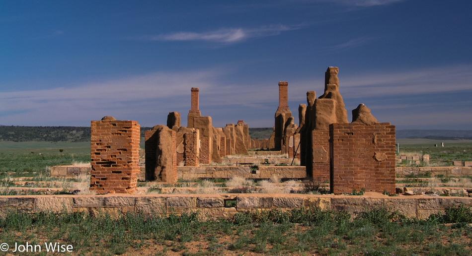
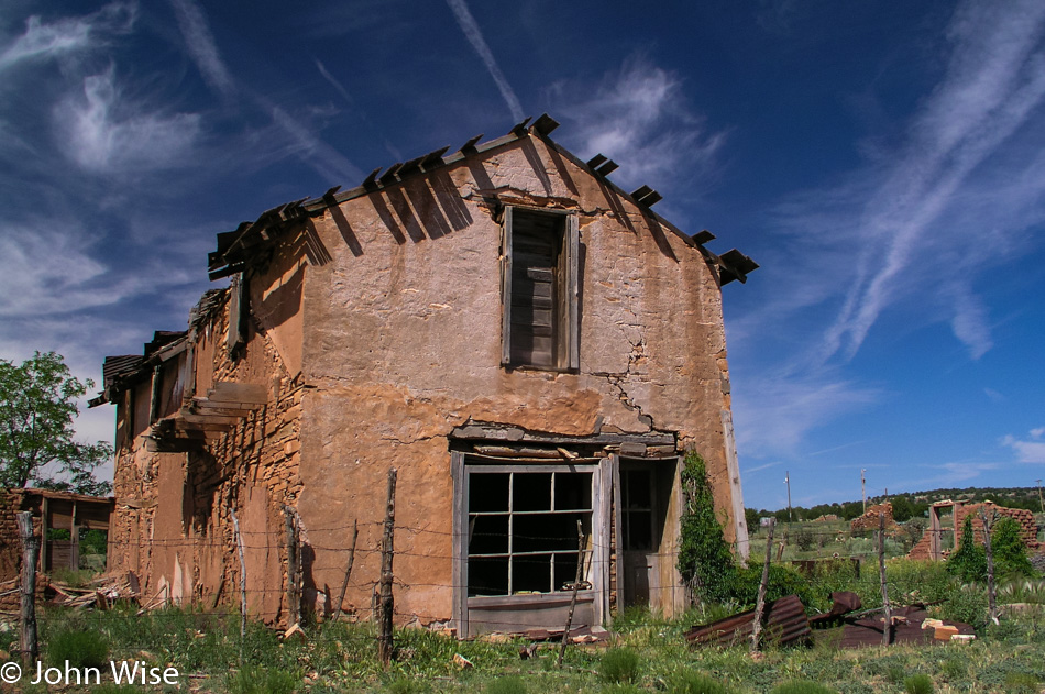
Back to Fort Union, the day couldn’t be better; a deep blue sky and high clouds with snow-capped mountains far on the horizon is our backdrop. The fort was established in 1851 and served as a guardian to the Santa Fe Trail for forty years. Over those years, three different forts had been constructed with the last two’s remains still visible.
The ruins are not better preserved as the land the fort had been built on was never properly acquired and was actually squatting on private land. As the fort’s land was given back to its owner and people at the time not being able to see the future importance of such a place, the owner allowed all takers to come in to remove bricks, fixtures, wood beams, and other miscellaneous building materials that were subsequently used on their own homes and farms.
For 65 years, the fort sat exposed to the elements before President Eisenhower signed into law the bill that established national monument status for the biggest military fort of its day west of the Mississippi.
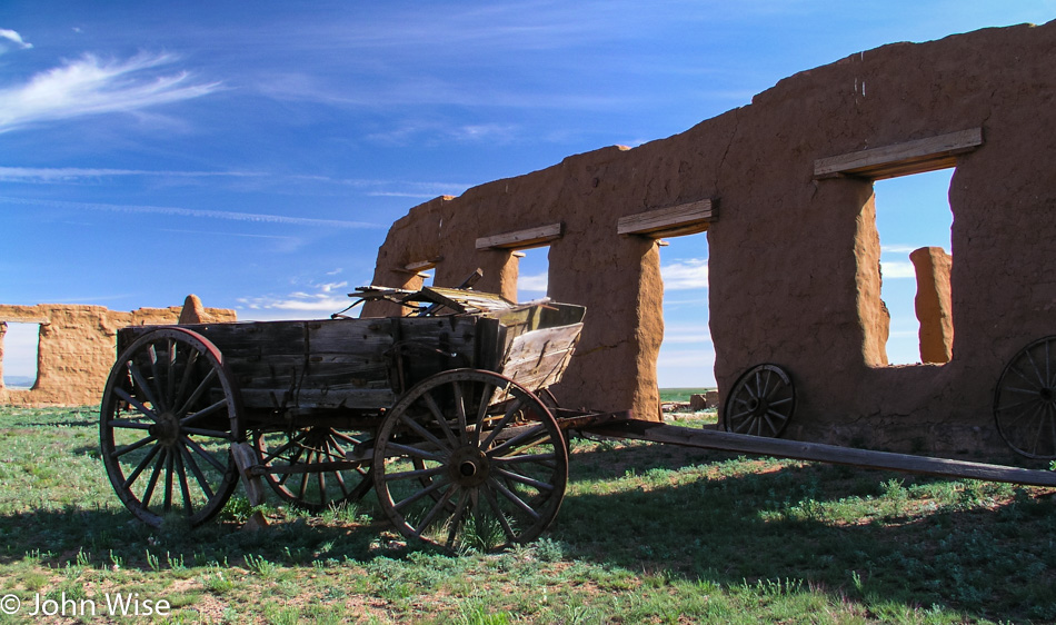
Visiting the ruins today, you walk down the original sidewalk, now cracked and buckling, past the remaining walls and chimneys. Some of the adobe walls still have original plaster holding tight to the walls that once gave refuge to soldiers protecting travelers of the Santa Fe Trail. A sundial still tells time much as it has for more than 100 years.
Some walls still stand over 12 feet tall and are the best preserved within the monument. Most of the structures were made of adobe, but a few remain made of stone. Amidst the walls, a number of old wagons, wheels, and farming implements still lay about. Thorny thistles poke out of the earth near the old stone jail. The cells were small and dark but quite cool, too; the cells probably offered the coolest location in the fort during the hot summers.
At the visitor’s center, we take a walk through a well-equipped museum that displays artifacts found during excavations over the years. On the western frontier, this is the most extensive and one of the most popular forts in the care of the park.
On Interstate 25 for a short while, then we turn off on Route 84 which is a surviving segment of old Route 66. Typical with many of the towns that were on the now-famous route, they fall into decline, and in some cases, they disappear altogether. Anton Chico is one of the towns that are having a difficult time hanging on. Many of the buildings are collapsing or abandoned and awaiting their ultimate demise.
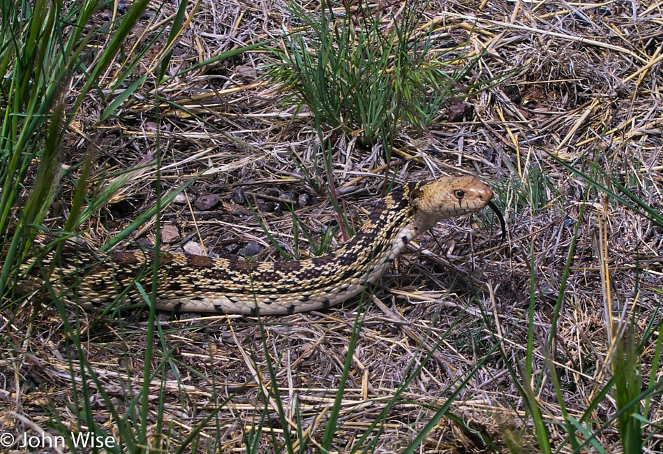
The old Route 66 must have been a scenic highway; the short segments we’ve traveled have always shown us the more beautiful parts of the country. We now dread the I-40, which replaced it; the interstate moves fast, with many a trucker pulling another load across the country on this congested superhighway. Only 26 miles down the I-40, and I’ve had enough. We turn off exit 230 south to Encino. Along the way, we pass a small lake and a snake trying to cross the blistering highway.
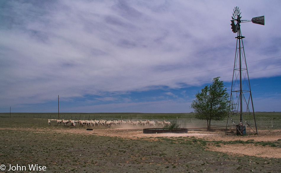
Further along, a small flock of sheep scurries across the desert, kicking up dust as they run off. Not far after Encino a small abandoned house with its electricity meter still running has been taken over by birds that are nesting throughout the home. The former ranch, its trailer home, and fencing are all in need of serious repair. No for sale sign sits outside not that I’m in a buying mood for this dilapidated old place anyway.
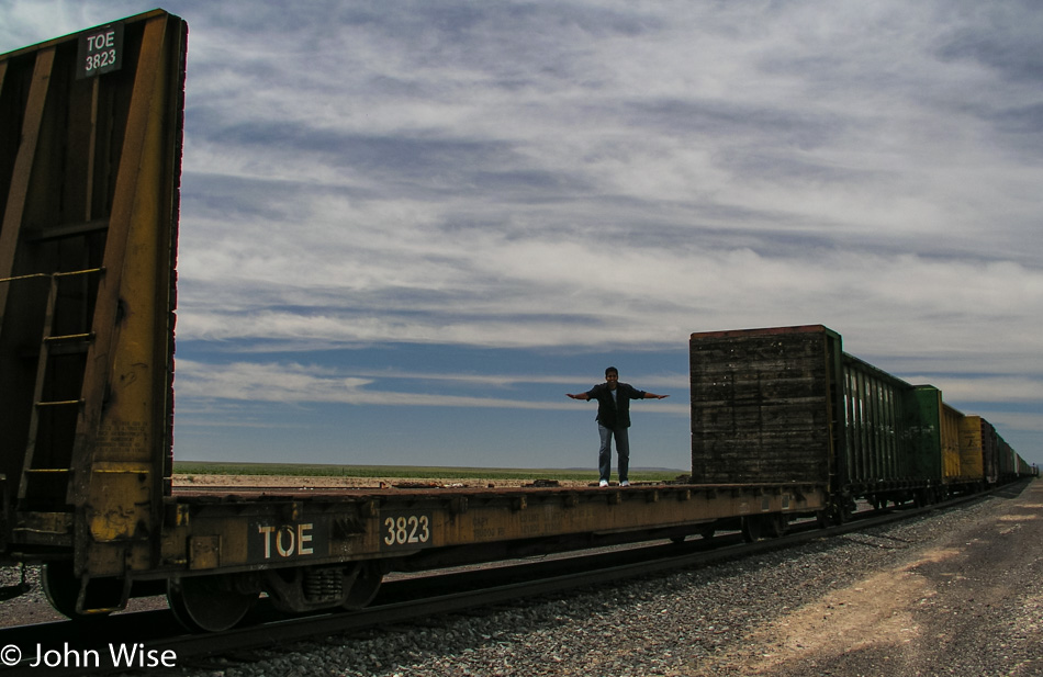
Jay jumped up on a train to get the feeling for what riding the rails across America might be like, more like surfing a train, I suppose. We pass a man walking across the desert who obviously doesn’t fit in the picture. I pull over to offer him some cold water, which he seems to appreciate, and we learn that he is Bob Brandkamp, who is on a ‘Road to Awareness” to help bring awareness to mental health. Bob is strolling across America. He is also mighty alone out here with some wide swaths of land to cover before coming upon another town that may or may not be inhabited. We wish him luck and then after leaving, wish we had given him one of our nice cold peach cups. Well, he is walking across America; I suppose he should be well prepared.
The land is austere, with short grasses and even smaller clusters of shrubs abounding. A dry salt lake stretches along the road for a while before our gaze returns to an empty land. At 12:30 we enter Mountainair and one minute later leave Mountainair. A half-hour after that we cross the Rio Grande and are now close to Socorro.
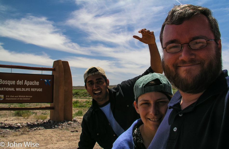
Socorro a favorite New Mexican town of ours. It is here that we stay when we go to the Bosque Del Apache Wildlife Refuge for bird watching in winter. The first inevitable stop is the El Camino Family Restaurant, the only restaurant we eat at here in Socorro. The El Camino is a New Mexican version of Denny’s. 24-7 breakfast is standard, but the New Mexican touch is that they will smother anything you order with green chili if that’s your wish. The food has a bite, is considerably better than Denny’s, and is inexpensive. If someone were to ask Caroline and me what our favorite top 10 restaurants in America are, I’m sure the El Camino would be on it.
We are in the area, so we make our way down the road for a short detour to the Bosque, the winter home to 10s of thousands of migratory birds. We spent a New Year’s Day here a couple of years ago and were rewarded with seeing more than 20,000 snow geese simultaneously lift off an iced-over lake as two eagles spooked them into action. The flapping and commotion of so many birds overhead brought tears to nearly every one of the 35 people who braved the 18-degree (-8 Celsius) morning to watch the large birds disperse. On another early spring visit, we listened to thousands of songbirds bring the refuge to a symphonic ecstasy.
Today, the refuge is nearly silent save for the wind rustling the grass. Some stragglers are in the few ponds that still have water. The grasses, though, are lushly green and taller than we’ve seen them at other times of the year. The wind blows just enough to make small waves on the water, and we, in turn, wave goodbye to the refuge.
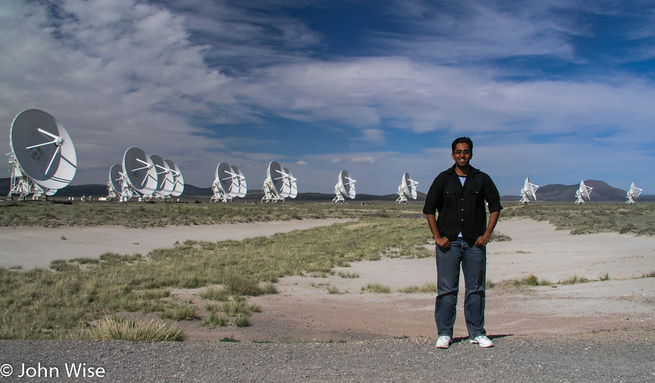
By the Rio Grande River again, we look for a place, any place to get down into the water but give up quickly with the need to return to Phoenix before midnight. North on the I-25 for a short time until Interstate 60 takes us west. The I-40 would be faster but is also so anticlimactic after such a rewarding long drive across so much beautiful land. Besides, just off the 60 is the VLA, also known as the Very Large Array.
The VLA gained fame after Jodie Foster, in her role in the film Contact, made the radio telescopes world-famous. Short on time, but with such dramatic skies, we take the turnoff to visit the VLA. Under these giant radio telescopes, the wind howls through their massive structures. Today, the ears listening to space are configured in such a way that all of the dishes are stacked close to the visitor center. On other visits, the array is spread across many a mile.
Pie Town, that famous locale for pies: we’ve been through here so many times we can no longer count them. Pie Town must surely be open to serving us some pie today because it is just not possible that this place can be closed every single time we come through. Wrong. It is closed, and we will have no pie. I’d tell you more about Pie Town, but then you might have the same curiosity we have only to never be able to satisfy that curiosity because Pie Town is never actually serving pie, or so it seems.
The road is quickly approaching Arizona just as fast as the sun drops in the sky. As if coordinating with the Arizona state welcome sign, the sun is nearly aligned behind the sun of our state’s flag.
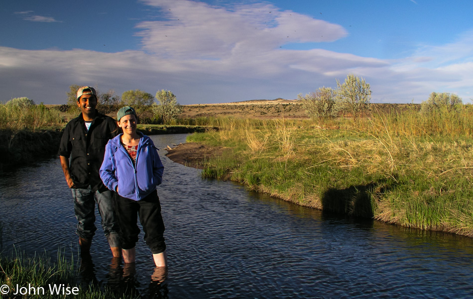
One more chance to step into a river has presented itself. Appropriately, it is the Little Colorado River. When the trip began, the first river that Caroline and Jay stepped into was the Colorado River; today, with only a few more hours before we got home, they stepped into the Little Colorado River.
Caroline, who has come down with a cold late on the trip closes her eyes and tries to get a little rest. The sun sets in the Tonto National Forest while we snake our way down and through the Salt River Canyon. At 10:48 p.m. after 6,132 miles, we are home.