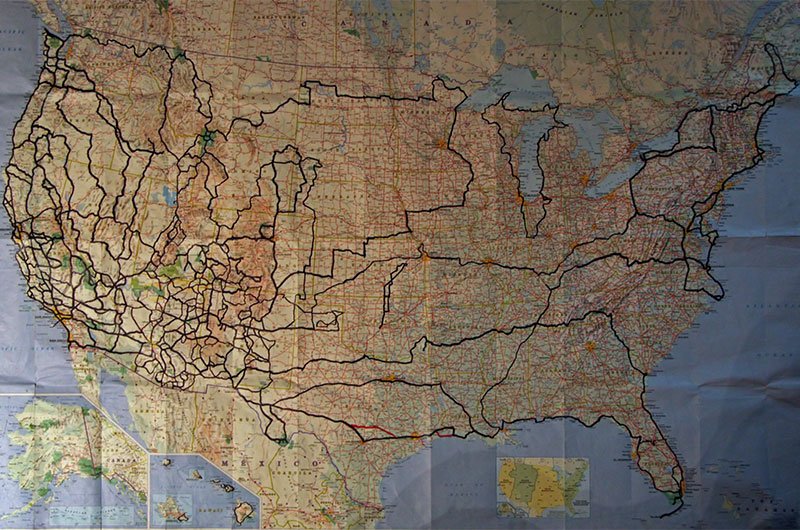
Two and a half years ago, I posted another photo of this map, which is quickly becoming more tape than paper. The map’s backside holds what must amount to yards of tape since the seams tend to fall apart after years of opening and closing this much-loved map. Many roads have now been traveled multiple times; our odometer will attest to the many miles driven north, south, and north again along the Oregon coast, for example. If you look closely and compare maps, you will see we have added a circumnavigation around Lake Michigan. In Maine we added Madawaska and Lubec to the list of furthest points outward that can be traveled in the lower 48 states; they join mile marker zero in Key West, Cape Flattery in Washington. By the way, we also found the geographical center of the United States, which lies in Lebanon, Kansas. Small sections of the eastern seaboard were driven, as was the shoreline of Lake Ontario and the St. Lawrence Seaway. We flew into Oklahoma City and made our way to Yarn School in Harveyville, Kansas, and prior to that spent the 4th of July in Canadian, Texas, visiting a rodeo and an old-fashioned town parade. A few small stretches of secondary roads in New Mexico were taken as prizes, adding to our road collection. Our upcoming travel plans will take us back to Oregon in November, Yellowstone in January, and the Northeast when my mother-in-law returns in April; not until next Thanksgiving will we likely see virgin road when we land in Atlanta, Georgia, for a road trip through the Old South. I don’t think many people outside of Presidential candidates will ever have the opportunity Caroline and I have made for ourselves to see so much of this great, big, beautiful country
Real nice! I’ve been tempted to "update" my own map as the newer maps have more roads on them that I’ve traveled and I think my similar map is about a decade old.
How old/recent is this map?
This map is current through today as the last three road trips made since October were over roads already taken. The map highlighting started in late 1999. Caroline sent me your map of travels you posted on Facebook, I find myself at once impressed but also feeling competitive and in need of adding more highlights to my map. Update your map and send me a photo so I can post it on my website, it would be interesting to see a collection of maps from those of us who have fallen in love with seeing America.